Earth observation methods have been important tools for forest management applications for several decades. Nevertheless, it is necessary to improve existing processes on the local and regional scales, in particular for retrieving biophysical forest attributes. TanDEM-X data with high spatial resolution are predestinated information sources for precise estimation of forest parameters such as tree height and aboveground biomass. Once the tree-scale estimates are validated across relevant forest types (e.g. deciduous forests, coniferous or mixed), these can be extrapolated to larger plot, watershed, regional or even national scales.
The utilization of three-dimensional remote sensing data sources like TanDEM-X and LIDAR for forest attribute estimation is an ongoing field of research. The derivation of forest parameters as a part of forest monitoring approaches is currently an important issue. This M.Sc thesis follows this idea by testing Tandem-X data using PolInSAR approach to derive forest parameters (e.g. height and aboveground biomass) for a small deciduous forest site in northeast Germany. A second pillar of research will focus on single tree-based estraction of tree heights using LiDAR point clouds. The results will be compared to enable drawing general and site-specific conclusions. Within the six-month project, the student will evaluate existing algorithms and processes and accordingly compare PolInSAR-, LiDAR- and field-based results. The aim is to improve the estimation of fundamental forest parameters such as forest height and biomass, in particular in context of Small-Scale Forest Inventories. The planned project will improve the calibration and validation of existing methods for analyzing Tandem-X datasets. It is worth mentioning that the methodology also entails estimation of potential errors and uncertainties.
This research will be carried out in the nature reserve Eldena, called Elisenhain. Established in 1961 and located in the southeast of Greifswald in Mecklenburg-Vorpommern, Germany. The protected area encompasses 407 ha and consists of mixed deciduous forests with high portions of European Beech (Fagus sylvatica) and common oak (Quercus robur). A small fraction of the whole nature reserve was chosen as test site, for which also reference field data have been already collected on aboveground biomass.
Briefly, the objective of this work is:
- To evaluate the capability of spaceborne TDX data to map essential forest inventory parameters by applying polarimetric and polarimetric SAR interferometry techniques.
- Ability to detect forest height and biomass at high spatial resolution using three-dimensional data sources including RADAR and LiDAR.
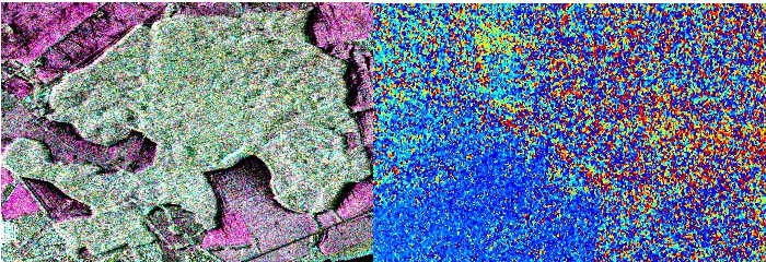
Test Site Location: Eldena, Greifswald with Tandem-X data (left) and Flat Earth Estimation and Removal (right)
In this regard, development and testing the existing models and algorithms to retrieve forest parameters from PolInSAR data will be performed to generate spatial maps of tree height, and biomass. Later, errors will be retrieved via validation with ground data and LiDAR data in terms of tree height and biomass.
Contact:
Dr. Nima Ahmadian (ahmadian.n@gmail.com)
Dr. Hooman Latifi (hooman.latifi@uni-wuerzburg.de)
Dept. of Remote Sensing, University of Würzbrug