PhD: Monitoring the structural parameters of forest habitats by multi-source/multi-temporal remote sensing data
The Department of Remote Sensing at the institute of Geography and Geology invites applications for a PhD position starting from May, 20th 2015 for a period of 3 years. The successful candidate will conduct her/his PhD with a multidisciplinary focus on remote sensing and spatial statistics.
Project Description:
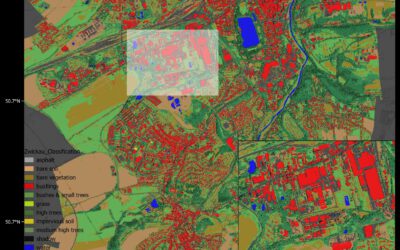
The structure of a natural forest landscape is characterized through elements such as the amount of foliage, canopy cover of woody plant species, structural properties of vegetation (i.e. diameter, basal area, vegetation height, aboveground biomass and amount of woody debris). Many of these (and other) factors related to the dynamics of a natural forest ecosystem (e.g. landscape structure, growing stock of forest stands, amount of coarse dead woody material and the vertical distribution of landscape elements) can presumably interact with natural disturbance agents such as biological infestations. Landscape structure can be assessed using remote sensing in a spatially and temporally continuous way. This project is part of a bigger framework on early detec-tion strategies for forest natural disturbance agents. In this part of the project, the derivations from various possible remote sensing sources (airborne and terrestrial LiDAR, UAV and possibly RADAR interferometry data) will be used to form a multi-temporal set of 3D information, which will further be applied to model the actual as well as changes in structural properties of selected natural forest habitats. The results will be validated by airborne- and field-based measurements on selected local test sites.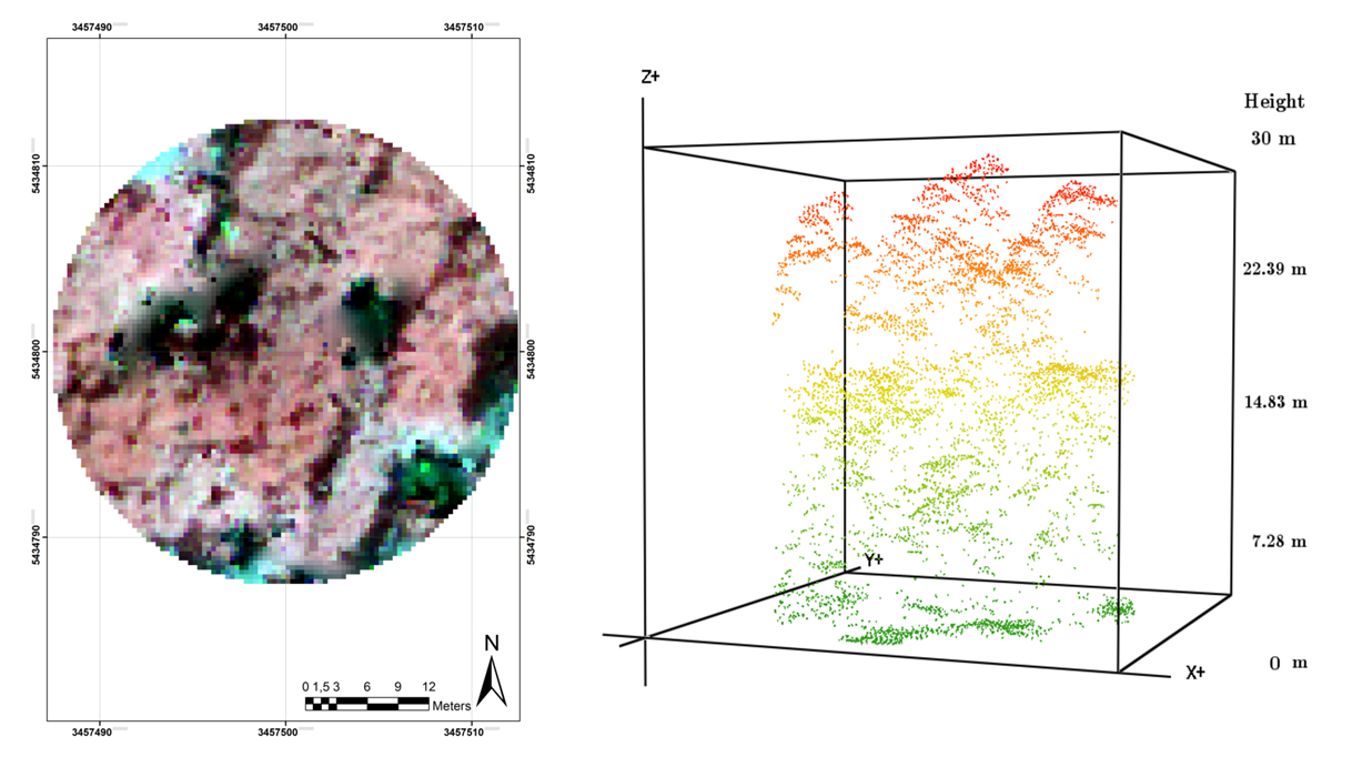
The methodology embraces a wide range from airborne-and spaceborne analysis of remote sensing products to statistical simulation of spatiotemporal processes. Therefore, the work additionally entails the use of ad-vanced spatial statistics. For gathering the required reference and validation data, a number of field trips are foreseen to the study site. A possible expansion of the results to further test sites in central Europe is also possible. The results of the work should be summarized in in scientific manuscripts intended for peer review presentation and publication.
Requirements:
― M.Sc. or Diploma degree or equivalent in geoinformatics, ecology (or forestry), physical geography or related fields,
― Sufficient knowledge and strong interest in remote sensing and spatial statistics,
― Advanced modelling/programming skills (preferably with R),
― Fluency in English. Knowledge of German language will be a great advantage.
― Interest in team integration and good teamwork skills.
The successful candidate will receive a PhD position for 24 + 12 months (TV-L E13/50%). Please submit your application (in English) containing a letter of interest, the CV, and – as one document – a detailed resume, a relevant recent research product (e.g. published article), and names and contact information of two academic references by E-Mail to:
Contact:
Dr. Hooman Latifi, University of Würzburg
E-Mail: hooman.latifi@uni-wuerzburg.de
Further information:
Application is opened until April 19th 2015. The University of Wuerzburg is an equal opportunity employer that tries to increase the number of women in research and teaching. Applicants with disabilities but otherwise equal qualifications will be preferred.