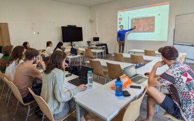
A remote sensing and GIS training for professional development aid staff members was conducted last month. Within 5 days the participants learned the basics of spatial data handling, creating maps, acquiring remote sensing data and earth observation products up to doing first steps in GoogleEarthEngine. The practical desktop exercises were done using QGIS and its powerful expression functions and geometry generators. Despite the challenging situation did we receive quite positive feedback about our virtual training but of course we are looking forward to do in-person trainings again once the are allowed.

The “Geolingual Studies” team visited the DLR EOC
The "Geolingual Studies" team of the University Würzburg visited the DLR-EOC on 3 and 4 July 2025. Geolingual Studies is an innovative area of research and teaching which takes a decisively applied linguistic approach and combines methodologies from linguistics,...