New R package! rsMove – Remote Sensing for Movement ecology

New R package! rsMove – Remote Sensing for Movement ecology

m

July 15, 2017

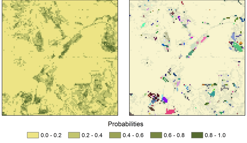
Application of segRaster(). On the left, a probability map. On the right, different colors represent unique regions with p > 0.5.

We are proud to announce that the initial version of rsMove is now available on CRAN. It was developed by Ruben Remelgado and offers utilities to analyze GPS tracking data using remote sensing such as directional and temporal sampling tools. While this package is directed towards animal ecology studies, its functions can be used for other applications involving, e.g., point data analyzes and image classification.

The package is hosted at gitHub and can be found here.

This initiative is part of the Opt4Environment project and was funded by the German Aerospace Center (DLR) on behalf of the Federal Ministry for Economic Affairs and Energy (BMWi) with the research grant 50 EE 1403. The movement data we used was provided by the Max Planck institute for Ornithology (MPIo). Click below to reach the involved parties.

you may also like:

EORC at the GfÖ Annual Symposium 2025 in Würzburg

EORC at the GfÖ Annual Symposium 2025 in Würzburg

Last week, EORC staff co-organized and partizipated in the Ecological Society of Germany, Austria and Switzerland (GfÖ) Annual Symposium 2025, this year hosted at University of Würzburg. The symposium, attended by more than 600 people, covered a wide range of topics...

New study on the conservation of biodiversity in West Africa

New study on the conservation of biodiversity in West Africa

A new study by our team, led by Insa Otte, on the conflict between biodiversity conservation in protected areas and agricultural development in West Africa has been published in the journal Natur und Landschaft. The abstract: According to the Human Development Report...

New study on invasive species in Rwanda

New study on invasive species in Rwanda

A new publication by EORC members Lilly Schell, Insa Otte, Sarah Schönbrodt-Stitt and Konstantin Müller, was just published   in the Journal Frontiers in Plant Science. Their study, “Synergistic use of satellite, legacy, and in situ data to predict spatio-temporal...

Poster Presentations at the GfÖ-Conference in Würzburg

Poster Presentations at the GfÖ-Conference in Würzburg

Being part of the organizers of this year's GfÖ-Conference in Würzburg our staff members Sonja Maas, Jakob Schwalb-Willmann and Maninder Singh Dhillon were happy to present the posters on their research topics today. The annual meeting of the GfÖ (Society for Ecology)...

Bridging Scales: How Radar Satellites supports Crop Monitoring

Bridging Scales: How Radar Satellites supports Crop Monitoring

In an era of climate uncertainty and increasing pressure on agricultural systems, understanding how crops grow and respond to environmental stress is more important than ever. A new study led by researchers from Martin-Luther-University Halle-Wittenberg, in close...