new publication on coast line dynamics

new publication on coast line dynamics

May 27, 2022

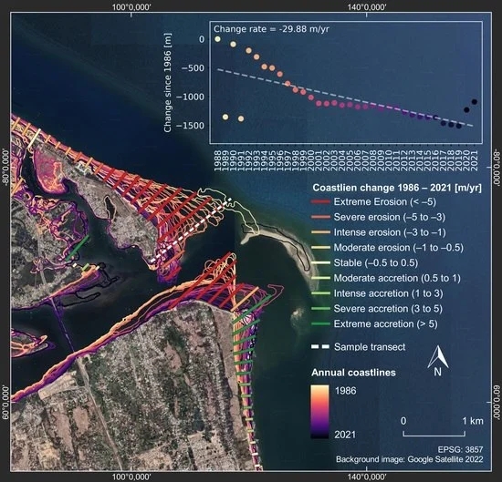
Ronja Lappe, a recent EAGLE graduate, published her thesis as article in Remote Sensing: “State of the Vietnamese Coast—Assessing Three Decades (1986 to 2021) of Coastline Dynamics Using the Landsat Archive”. From the abstract: “Vietnam’s 3260 km coastline is densely populated, experiences rapid urban and economic growth, and faces at the same time a high risk of coastal hazards. Satellite archives provide a free and powerful opportunity for long-term area-wide monitoring of the coastal zone. This paper presents an automated analysis of coastline dynamics from 1986 to 2021 for Vietnam’s entire coastal zone using the Landsat archive. The proposed method is implemented within the cloud-computing platform Google Earth Engine to only involve publicly and globally available datasets and tools. We generated annual coastline composites representing the mean-high water level and extracted sub-pixel coastlines. We further quantified coastline change rates along shore-perpendicular transects, revealing that half of Vietnam’s coast did not experience significant change, while the remaining half is classified as erosional (27.7%) and accretional (27.1%). A hotspot analysis shows that coastal segments with the highest change rates are concentrated in the low-lying deltas of the Mekong River in the south and the Red River in the north. Hotspots with the highest accretion rates of up to +47 m/year are mainly associated with the construction of artificial coastlines, while hotspots with the highest erosion rates of −28 m/year may be related to natural sediment redistribution and human activity.”

read the full article here: Lappe, R.; Ullmann, T.; Bachofer, F. State of the Vietnamese Coast—Assessing Three Decades (1986 to 2021) of Coastline Dynamics Using the Landsat Archive. Remote Sens. 2022, 14, 2476. https://doi.org/10.3390/rs14102476

you may also like:

Bridging Scales: How Radar Satellites supports Crop Monitoring

Bridging Scales: How Radar Satellites supports Crop Monitoring

In an era of climate uncertainty and increasing pressure on agricultural systems, understanding how crops grow and respond to environmental stress is more important than ever. A new study led by researchers from Martin-Luther-University Halle-Wittenberg, in close...

New paper on automated pollinator monitoring using time-lapse images

New paper on automated pollinator monitoring using time-lapse images

Researchers from Helmholtz Centre for Environmental Research (UFZ) in Leipzig, the German Centre for Integrative Biodiversity Research (iDiv) in Leipzig, the Martin Luther University Halle-Wittenberg, the German Remote Sensing Data Center (DFD) of the German Aerospace...

Media reporting on “understanding urban heat in Germany”

Media reporting on “understanding urban heat in Germany”

We recently reported on the urban heat island effect in Germany and the work of DLR and EORC on the topic – please see here: https://remote-sensing.org/understanding-urban-heat-in-germany-insights-from-prof-hannes-taubenbocks-research/   Here is a link to...

Proceedings of JURSE published

Proceedings of JURSE published

Our EORC and our colleagues from DLR have contributed with various research works to the Joint Urban Remote Sensing Event (JURSE) 2025. This bi-annual conference took place in Tunis, Tunisia, in early May 2025. JURSE is committed to introduce innovative methodologies...

DLR supports Zeit Magazine with Land Surface Temperature data

DLR supports Zeit Magazine with Land Surface Temperature data

Our colleagues from DLR provided long-term Land Surface Temperature (LST) data for an interactive tool in the Zeit Magazine which was recently published online https://www.zeit.de/zeit-magazin/2025-06/stadtteile-grossstaedte-wohnen-deutschland-lebensqualitaet The tool...