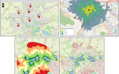
A new article on “The Individual Walkable Neighborhood – Evaluating people-centered spatial units focusing on urban density” was just published by Ariane Droin, Michael Wurm and Hannes Taubenböck on a people-centered approach towards meaningful reference areas describing the living environment within walking distance around the place of residence. From the abstract: “Urban planners are concerned to design the city in a way that supports quality of life. To catch how the settings of elements in space influence our subjective perception is difficult to evaluate, especially since objective measures are normally calculated at arbitrary scales. To better focus on the actual surrounding of individuals, people-centered reference areas are needed. The current study presents a comparison of three different people-centered reference areas which vary in their generalization of space: the Buffer, the Convex Hull of a routing network, and the “Individual Walkable Neighborhood”. The latter reference areas are based on the streets an individual can reach within a certain amount of time. We compare the 3D-density of these three different reference areas and of arbitrary reference areas like city blocks in a quantitative and geographical way for the city of Munich. With this we can clearly show that it is crucial to focus on such people-centered reference areas, and that even at this very small scale big differences in density values can occur. Using navigational principles, a much more lifelike and realistic representation of the subjective neighborhood can be achieved, which should provide a basis for urban practitioners when combining objective variables to the subjective perception.”
read the full article here: https://www.sciencedirect.com/science/article/pii/S0198971522001375 ”