


follow us and share it on:
you may also like:

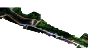
Mapping Lava Tubes on Mauritius with iPhone Pro LiDAR
Lava tube structures on Mauritius are quite hard to survey - tight, dark, and largely inaccessible to classical scanning equipment. As part of ongoing research by Dr. Kim Lea Holzmann (Chair of Animal Ecology and Tropical Biology, University of Würzburg), we're...

Johannes Mast wins Bernd Rendel Prize
Johannes Mast is awarded the 2026 Bernd Rendel Prize for Geosciences by the Deutsche Forschungsgemeinschaft (DFG) for outstanding research as part of his dissertation. Johannes’s highly interdisciplinary work bridges the Geosciences, Linguistics, Data Science, and...

Two days of celebration, and a hundred hands behind it
We've written plenty about the EORC 25th and EAGLE 10th anniversary already, the timeline, the talks, the EAGLE panel discussion, the exhibition. But there's a story we haven't told yet, and it's honestly the one that matters at least as much. Because none of it just...

From Banner to Pencil Case: Our Anniversary Banner gets a Second Life
Anyone who was at the big celebration on July 16th remembers the banner. Big, 1 by 4 meters, printed for the occasion: 25 years of EORC and 10 years of EAGLE, a huge strip of fabric. It did its job beautifully for the weeks before the event and especially for our two...

Earth Observation Meets Agricultural Practice: The Final Excursion of the EAGLE Block Course
The EAGLE block course "Linking Science and Practice in Earth Observation for Climate Adaptation" concluded with a visit to the Bavarian State Office for Agriculture (LfL) and its Research Center for Agriculture in Dry Regions in Schwarzenau. Following earlier visits...

Small Gesture, Big Thanks: Chocolate in the Polar Bear Kitchen
Pulling off a party for 250 people doesn't happen by magic. It happens because a bunch of people quietly say yes to the boring jobs, the carrying, the setting up, the standing around answering questions, the cleaning up afterward. Our combined 25th anniversary for...