Thermal mapping within the MonitAnt project

Thermal mapping within the MonitAnt project

m

August 4, 2024

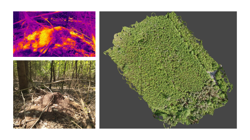
In collaboration with Prof. Heike Feldhaar from the University of Bayreuth we explored the potential of UAS data to map ant mounds within forests automatically. Such an approach would help ecologists to analyse the spatial pattern of mounds and also its changes over time within larger areas.

The UAS team performed the field work in a forest area close to Haßfurt, Lower Franconia, within the scope of the project MonitAnt. MonitAnt aims to develop a harmonized, efficient, and cost-effective monitoring strategy that is freely available to various stakeholders to enable long-term monitoring of population trends of mound-building Formica ants and associated myrmecophiles across Europe.

Within the project we are collecting and processing the geospatial data; thus, analysing if the ant mounds can be detected within different data sets. Our team members operated various drones by mounting multispectral and thermal cameras as well as LIDAR instruments. Besides, the study is supported by ground-truth data to test the accuracy of the aerial images. The ground in-situ data, in particular, revealed important insights about the reflectance characteristics of the ant mounds.

On the long run the main aim is to develop an European-level Monitoring strategy for mound-building Formica Ants and symbiont communities residing in nest mounds.

you may also like:

A Glimpse into Our Research: Data on Display in the Foyer

A Glimpse into Our Research: Data on Display in the Foyer

Stepping into the foyer, visitors are now greeted by large, striking images that tell the story of our research through data. Each visual represents a unique scientific perspective – from the Arctic to the cultivated landscapes of Bavaria, and from forest canopies to...

Successful MSc defense by Sonja Maas

Successful MSc defense by Sonja Maas

Big congratulations to Sonja Maas, who successfully defended her Master thesis today on the highly relevant and increasingly pressing topic: LiDAR-Based Acquisition Strategies for Forest Management Planning in a Mature Beech Stand Supervised by Dr. Julian Fäth and...

Visit at the Institute for Geoinformatics (IFGI) at University of Münster

Visit at the Institute for Geoinformatics (IFGI) at University of Münster

Two days ago, our PostDoc Dr. Jakob Schwalb-Willmann visited the Institute for Geoinformatics at University of Münster to give a talk at IFGI’s GI Forum titled “Can animals be used to classify land use? Employing movement-tracked animals as environmental informants using deep learning”.