New publication on a “Do-it-yourself built-up mapping tool”
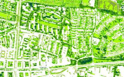
Researchers from the Earth Observation Center (EOC) of the German Aerospace Center (DLR) in Oberpfaffenhofen, the Image Processing Laboratory of the University of València, Spain and our Earth Observation Research Cluster (EORC) of the University of Würzburg teamed up for a study on mapping urban expansion. The paper titled “Do-it-yourself built-up mapping tool: A practical cloud-based solution using Sentinel imagery for mapping urban expansion in Africa” was just published in the International Journal of Applied Earth Observation and Geoinformation by Marta Sapena, Johannes Mast, Elisabeth Schöpfer and Hannes Taubenböck.
Here is the abstract of the paper: Urban areas across Africa have undergone unprecedented growth, posing significant challenges for sustainable development, infrastructure planning, and climate resilience. Existing mapping products often struggle to capture the dynamic and heterogeneous nature of these evolving urban landscapes, highlighting the need for maps that are both up-to-date and locally relevant. This study introduces a practical, cloud-based solution: an online tool for site-specific mapping (i.e., tailored maps for a defined area of interest) that leverages the capabilities of Google Earth Engine. The tool uses Sentinel-1 and Sentinel-2 imagery to derive a wide range of spectral and texture metrics, supplemented by terrain data, and is trained using open building footprint datasets available for 2022. In an experimental setup, nine model configurations were tested under varying data availability conditions across 100 urban sites in Africa. The best-performing model achieved a mean F1-score of 0.59 (recall 0.63; precision 0.51) when validated against building footprints, with higher accuracy observed in dense urban areas. This configuration was integrated into the freely available ‘Do-it-yourself built-up mapping tool’ (DIY-BU). A quantitative analysis across the 100 test sites showed that the maps generated by our tool for 2022 were substantially more accurate (with an increase of F1-score by 0.18–0.30) than global multi-temporal products analysed for the same period (i.e., Dynamic World, ESRI land cover, GISA, GLC_FCS30D and GISD30). While the quantitative assessment was limited to the 2022 reference year, and the multi-temporal maps rely on a monotonic growth assumption (preventing the detection of demolition), a qualitative analysis highlighted the tool’s advantages in capturing detailed urban expansion and small-scale structures. The DIY-BU-mapping tool offers a valuable resource for a variety of applications, including urban planning, infrastructure monitoring, disaster preparedness and climate adaptation. Beyond presenting the tool’s functionality, the paper discusses its limitations and potential applications across diverse geographic and data availability contexts.
Here is the link to the full paper: https://www.sciencedirect.com/science/article/pii/S1569843226000695?via%3Dihub
This research contributes to our works on global urbanization, and particularly on remote sensing applications in the African context – for some further reading on recent papers, please see here:
- Africa’s digital urban frontier: Inequality in social media activity between consolidated and newly urbanized areas in Africa https://www.sciencedirect.com/science/article/pii/S0143622825001821
- Spatial delineations of cities based on web content and built-up age – a case study on North African growth poles from 2010 to 2020 https://ieeexplore.ieee.org/abstract/document/11076073
- Integrating multi-source remote sensing data for monitoring urban development in West Africa https://ieeexplore.ieee.org/document/10144165
- Was global urbanization from 1985 to 2015 efficient in terms of land consumption? https://www.sciencedirect.com/science/article/pii/S0197397525001134
- Global differences in urbanization dynamics from 1985 to 2015 and outlook considering IPCC climate scenarios https://www.sciencedirect.com/science/article/pii/S0264275124003317
- The unseen – An Investigative Analysis of Thematic and Spatial Coverage of News on the Ongoing Refugee Crisis in West Africa https://www.mdpi.com/2220-9964/12/4/175
- The migrant perspective – Measuring migrants’ movements and interests using geolocated tweets https://onlinelibrary.wiley.com/doi/10.1002/psp.2732
- How Do Rural Industrial Sites Impact Migrant Motives and the Socio-Economic Conditions of Local and Migrant Populations https://www.sciencedirect.com/science/article/pii/S2468227625000171
- A comparative assessment of data-driven flood susceptibility mapping in Nigeria https://link.springer.com/article/10.1007/s11069-025-07868-y
- Mining-Driven Settlement Dynamics: Evidence from the Cobalt Belt in the Democratic Republic of Congo https://ieeexplore.ieee.org/document/11076051