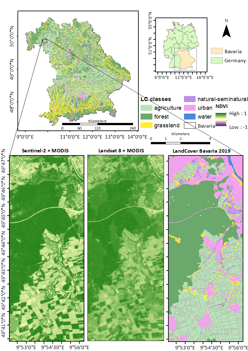
We are glad to share with you our newest publication on “Spatiotemporal Fusion Modelling Using STARFM: Examples of Landsat 8 and Sentinel-2 NDVI in Bavaria” in the open-access journal Remote Sensing by MDPI.
From the abstract: The increasing availability and variety of global satellite products provide a new level of data with different spatial, temporal, and spectral resolutions; however, identifying the most suited resolution for a specific application consumes increasingly more time and computation effort. The region’s cloud coverage additionally influences the choice of the best trade-off between spatial and temporal resolution, and different pixel sizes of remote sensing (RS) data may hinder the accurate monitoring of different land cover (LC) classes such as agriculture, forest, grassland, water, urban, and natural-seminatural. To investigate the importance of RS data for these LC classes, the present study fuses NDVIs of two high spatial resolution data (high pair) (Landsat (30 m, 16 days; L) and Sentinel-2 (10 m, 5–6 days; S), with four low spatial resolution data (low pair) (MOD13Q1 (250 m, 16 days), MCD43A4 (500 m, one day), MOD09GQ (250 m, one-day), and MOD09Q1 (250 m, eight day)) using the spatial and temporal adaptive reflectance fusion model (STARFM), which fills regions’ cloud or shadow gaps without losing spatial information. These eight synthetic NDVI STARFM products (2: high pair multiply 4: low pair) offer a spatial resolution of 10 or 30 m and temporal resolution of 1, 8, or 16 days for the entire state of Bavaria (Germany) in 2019. Due to their higher revisit frequency and more cloud and shadow-free scenes (S = 13, L = 9), Sentinel-2 (overall R2 = 0.71, and RMSE = 0.11) synthetic NDVI products provide more accurate results than Landsat (overall R2 = 0.61, and RMSE = 0.13). Likewise, for the agriculture class, synthetic products obtained using Sentinel-2 resulted in higher accuracy than Landsat except for L-MOD13Q1 (R2 = 0.62, RMSE = 0.11), resulting in similar accuracy preciseness as S-MOD13Q1 (R2 = 0.68, RMSE = 0.13). Similarly, comparing L-MOD13Q1 (R2 = 0.60, RMSE = 0.05) and S-MOD13Q1 (R2 = 0.52, RMSE = 0.09) for the forest class, the former resulted in higher accuracy and precision than the latter. Conclusively, both L-MOD13Q1 and S-MOD13Q1 are suitable for agricultural and forest monitoring; however, the spatial resolution of 30 m and low storage capacity makes L-MOD13Q1 more prominent and faster than that of S-MOD13Q1 with the 10-m spatial resolution.
Full article: Dhillon, M.S.; Dahms, T.; Kübert-Flock, C.; Steffan-Dewenter, I.; Zhang, J.; Ullmann, T. Spatiotemporal Fusion Modelling Using STARFM: Examples of Landsat 8 and Sentinel-2 NDVI in Bavaria. Remote Sens. 2022, 14, 677. https://doi.org/10.3390/rs14030677


