New publication: Towards an all-in-one sensor for forestry applications?

New publication: Towards an all-in-one sensor for forestry applications?

March 27, 2017

A recent paper published by Forestry and featuring Dr. Hooman Latifi from Dept. of Remote Sensing presents novel results of estimating most relevant forest inventory attributes from very high resolution stereoscopic satellite imagery.  The paper couples a systematic review of the state-of-the-art in photogrammetry-basad forest attribute estimation, a case study in southwestern Germany and an expert survey on the potenaitls and pitfalls of remote sensing-assisted forest inventory, in which internationally renowned peers from all over the world took part.


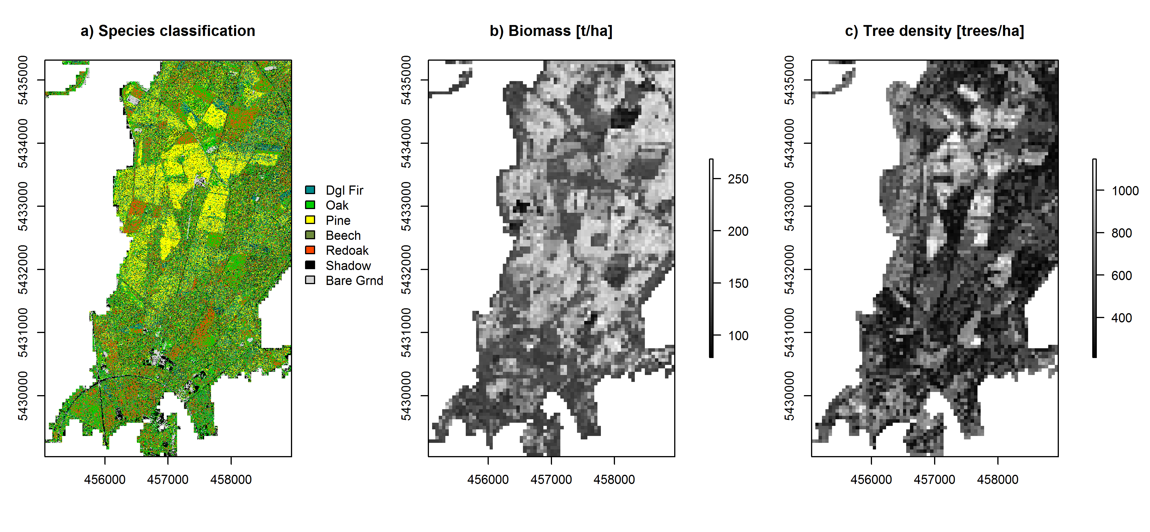
Area-based predictions of tree species, aboveground biomass and tree density based on WorldView-2 stereo data


The modeling/classification results were comparable to earlier studies in the same test site, obtained with more expensive airborne acquisitions. All in all, the study concludes that the simpler acquisition, reasonable price and the comparably easy data format and handling of VHRSI compared with other sensor types justifies further research on the application of these data for supporting operational forest inventories. The fulltext version of the paper together with the supplementary material can be found here.

Fassnacht, F.E., Mangold, D., Schäfer, J., Immitzer, M., Kattenborn, T., Koch, B and Latifi, H. 2017. Estimating stand density, biomass and tree species from very high resolution stereo-imagery – towards an all-in-one sensor for forestry applications? Forestry, DOI: 10.1093/forestry/cpx014


you may also like:

Our research site and project covered by BR

Our research site and project covered by BR

The University forest at Sailershausen is a unique forest owned by the University of Wuerzburg. It comes with a high diversity of trees and most important is part of various research projects. We conducted various UAS/UAV/drone flights with Lidar, multispectral and...

Meeting of the FluBig Project Team

Meeting of the FluBig Project Team

During the last two days, the team of the FluBig project (remote-sensing.org/new-dfg-project-on-fluvial-research/) met at the EORC for discussing the ongoing work on fluvial biogeomorphology. After returning from a successful field expedition to Kyrgyzstan a couple of...

‘Super Test Site Würzburg’ project meeting

‘Super Test Site Würzburg’ project meeting

After the successful "Super Test Site Würzburg" measurement campaign in June (please see here: https://remote-sensing.org/super-test-site-wurzburg-from-the-idea-to-realization/ ), the core team from the University of Würzburg, the Karlsruhe Institute of Technology,...

EORC Talk: Geolingual Studies: A New Research Direction

EORC Talk: Geolingual Studies: A New Research Direction

On July 19th, Lisa Lehnen and Richard Lemoine Rodríguez, two postdoctoral researchers of the Geolingual Studies project, gave an inspiring presentation at the EORC talk series.   In the talk titled "Geolingual Studies – a new research direction", they...

EO support for UrbanPArt field work

EO support for UrbanPArt field work

From May to September, Karla Wenner, a PhD student at the Juniorprofessorship for Applied Biodiversity Science, will be sampling urban green spaces and semi-natural grasslands in Würzburg as part of the UrbanPArt project. Our cargo bikes support the research project...

Cinematic drone shots

Cinematic drone shots

We spend quite some time in the field conducting field work, from lidar measurements to vegetation samples in order to correlate it with remote sensing data to answer various research questions concerning global change. Field work is always a 24/7 work load and...