Congratulations to Sophie for handing in her PhD thesis! Her research focused on “Earth Observation Time Series for Grassland Management Analyses – Development and large-scale Application of a Framework to detect Grassland Mowing Events in Germany”.
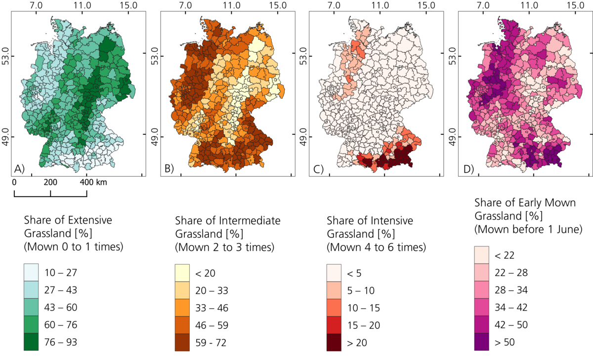
From the abstract: ” Grasslands shape many landscapes of the earth as they cover about one-third of its surface. They are home and provide livelihood for billions of people and are mainly used as source of forage for animals. However, grasslands fulfill many additional ecosystem functions next to fodder production, such as storage of carbon, water filtration, provision of habitats and cultural values. They play a role in climate change (mitigation) and in preserving biodiversity and ecosystem functions on a global scale. The degree to what these ecosystem functions are present within grassland ecosystems is largely determined by the management. Individual management practices and the use intensity influence the species composition as well as functions, like carbon storage, while higher use intensities (e.g. high mowing frequencies) usually show a negative impact. Especially in Central European countries, like in Germany, the determining influence of grassland management on its physiognomy and ecosystem functions leads to a large variability and small-scale alternations of grassland parcels. Large-scale information on the management and use intensity of grasslands is not available. Consequently, estimations of grassland ecosystem functions are challenging which, however, would be required for large-scale assessments of the status of grassland ecosystems and optimized management plans for the future. The topic of this thesis tackles this gap by investigating the major grassland management practice in Germany, which is mowing, for multiple years, in high spatial resolution and on a national scale. Earth Observation (EO) has the advantage of providing information of the earth’s surface on multi-temporal time steps. An extensive literature review on the use of EO for grassland management and production analyses, which was part of this thesis, showed that in particular research on grasslands consisting of small parcels with a large variety of management and use intensity, like common in Central Europe, is underrepresented. Especially the launch of the Sentinel satellites in the recent past now enables the analyses of such grasslands due to their high spatial and temporal resolution. The literature review specifically on the investigation of grassland mowing events revealed that most previous studies focused on small study areas, were exploratory, only used one sensor type and/or lacked a reference data set with a complete range of management options. Within this thesis a novel framework to detect grassland mowing events over large areas is presented which was applied and validated for the entire area of Germany for multiple years (2018–2021). The potential of both sensor types, optical (Sentinel-2) and synthetic aperture radar (SAR) (Sentinel-1) was investigated regarding grassland mowing event detection. Eight EO parameters were investigated, namely the Enhanced Vegetation Index (EVI), the backscatter intensity and the interferometric (InSAR) temporal coherence for both available polarization modes (VV and VH), and the polarimetric (PolSAR) decomposition parameters Entropy, K0 and K1. An extensive reference data set was generated based on daily images of webcams distributed in Germany which resulted in mowing information for grasslands with the entire possible range of mowing frequencies – from one to six in Germany – and in 1475 reference mowing events for the four years of interest. For the first time, an observation-driven mowing detection approach including data from Sentinel-2 and Sentinel-1 and combining the two was developed, applied and validated on large scale. Based on a subset of the reference data (13 grassland parcels with 44 mowing events) from 2019 the EO parameters were investigated and the detection algorithm developed and parameterized. This analysis showed that a threshold-based change detection approach based on EVI captured grassland mowing events best, which only failed during periods of clouds. All SAR-based parameters showed a less consistent behavior to mowing events, with PolSAR Entropy and InSAR Coherence VH, however, revealing the highest potential among them. A second, combined approach based on EVI and a SARbased parameter was developed and tested for PolSAR Entropy and InSAR VH. To avoid additional false positive detections during periods in which mowing events are anyhow reliably detected using optical data, the SAR-based mowing detection was only initiated during long gaps within the optical time series (>25 days). Application and validation of these approaches in a focus region revealed that only using EVI leads to the highest accuracies (F1-Score = 0.65) as combining this approach with SAR-based detection led to a strong increase in falsely detected mowing events resulting in a decrease of accuracies (EVI + PolSAR ENT F1-Score = 0.61; EVI + InSAR COH F1-Score = 0.61). The mowing detection algorithm based on EVI was applied for the entire area of Germany for the years 2018-2021. It was revealed that the largest share of grasslands with high mowing frequencies (at least four mowing events) can be found in southern/south-eastern Germany. Extensively used grassland (mown up to two times) is distributed within the entire country with larger shares in the center and north-eastern parts of Germany. These patterns stay constant in general, but small fluctuations between the years are visible. Early mown grasslands can be found in southern/south-eastern Germany – in line with high mowing frequency areas – but also in central-western parts. The years 2019 and 2020 revealed higher accuracies based on the 1475 mowing events of the multi-annual validation data set (F1-Scores of 0.64 and 0.63), 2018 and 2021 lower ones (F1-Score of 0.52 and 0.50). Based on this new, unprecedented data set, potential influencing factors on the mowing dynamics were investigated. Therefore, climate, topography, soil data and information on conservation schemes were related to mowing dynamics for the year 2020, which showed a high number of valid observations and detection accuracy. It was revealed that there are no strong linear relationships between the mowing frequency or the timing of the first mowing event and the investigated variables. However, it was found that for intensive grassland usage certain climatic and topographic conditions have to be fulfilled, while extensive grasslands appear on the entire spectrum of these variables. Further, higher mowing frequencies occur on soils with influence of ground water and lower mowing frequencies in protected areas. These results show the complex interplay between grassland mowing dynamics and external influences and highlight the challenges of policies aiming to protect grassland ecosystem functions and their need to be adapted to regional circumstances.