Thermal mapping within the MonitAnt project

Thermal mapping within the MonitAnt project

m

August 4, 2024

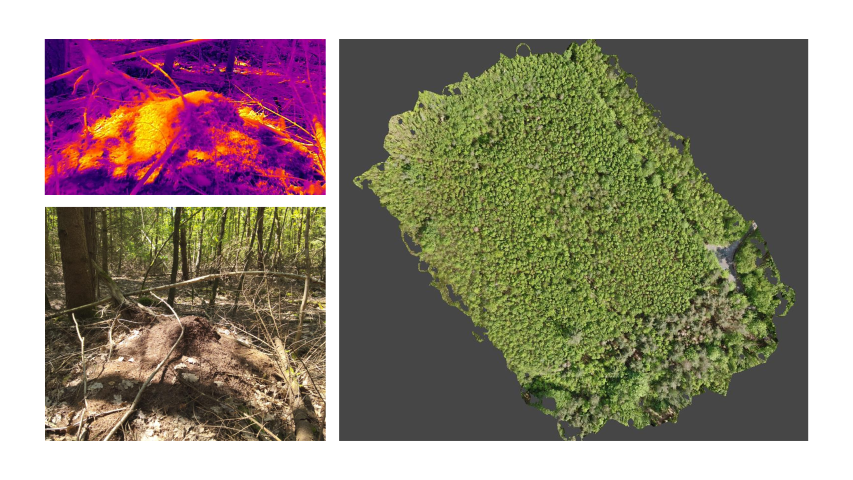
In collaboration with Prof. Heike Feldhaar from the University of Bayreuth we explored the potential of UAS data to map ant mounds within forests automatically. Such an approach would help ecologists to analyse the spatial pattern of mounds and also its changes over time within larger areas.

The UAS team performed the field work in a forest area close to Haßfurt, Lower Franconia, within the scope of the project MonitAnt. MonitAnt aims to develop a harmonized, efficient, and cost-effective monitoring strategy that is freely available to various stakeholders to enable long-term monitoring of population trends of mound-building Formica ants and associated myrmecophiles across Europe.

Within the project we are collecting and processing the geospatial data; thus, analysing if the ant mounds can be detected within different data sets. Our team members operated various drones by mounting multispectral and thermal cameras as well as LIDAR instruments. Besides, the study is supported by ground-truth data to test the accuracy of the aerial images. The ground in-situ data, in particular, revealed important insights about the reflectance characteristics of the ant mounds.

On the long run the main aim is to develop an European-level Monitoring strategy for mound-building Formica Ants and symbiont communities residing in nest mounds.

you may also like:

PhD position: Earth Observation of drought and fire impacts

PhD position: Earth Observation of drought and fire impacts

Job Announcement: PhD Position on EO research of Drought, Fire and Vegetation in Kruger National Park, South Africa Position: PhD ResearcherStudy Area: Kruger National Park, South AfricaApplication Deadline: until position is filledStart Date: as soon as possible...

Exchange with colleagues from AIT Austrian Institute of Technology

Exchange with colleagues from AIT Austrian Institute of Technology

On 16 January 2025, Ariane Droin, Henri Debray and Hannes Taubenböck from EORC and the EOC of DLR were invited to the AIT Austrian Institute of Technology GmbH in Vienna as part of the UrbanSky project. The Urban Sky research project is carrying out a needs and...

Empowering Students with SAGA GIS for Environmental Applications

Empowering Students with SAGA GIS for Environmental Applications

At EAGLE Earth Observation, we are committed to equipping our students with the tools and knowledge needed to excel in the field of environmental science. As part of this effort, our students are exploring the power of various scientific open-source software packages...

EUSI meets GZS

EUSI meets GZS

Following the European Space Imaging Conference (EUSI) in December 2024 (DLR and EORC contributed to the conference. We reported on this – please see here: https://remote-sensing.org/keynote-presentation-at-eusi-conference-2024/), the long-standing partners met...

Successful Master Thesis Defense by Konstantin Müller

Successful Master Thesis Defense by Konstantin Müller

On January 14th, Konstantin Müller successfully defended his master’s thesis titled "Animal Path Segmentation and Analysis via Generalized Deep Neural Network Regression". Supervised by Jakob Schwalb-Willmann and Dr. Mirjana Bevanda, the presentation was delivered to...