new publication on LST distribution

new publication on LST distribution

October 10, 2022

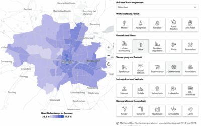
A new paper by Hannes Taubenböck and his team titled “Seasonal and Diurnal Variation of Land Surface Temperature Distribution and Its Relation to Land Use/Land Cover Patterns” has been published in the International Journal of Environmental Research and Public Health. From the abstract: “The surface urban heat island (SUHI) affects the quality of urban life. Because varying urban structures have varying impacts on SUHI, it is crucial to understand the impact of land use/land cover characteristics for improving the quality of life in cities and urban health. Satellite-based data on land surface temperatures (LST) and derived land use/cover pattern (LUCP) indicators provide an efficient opportunity to derive the required data at a large scale. This study explores the seasonal and diurnal variation of spatial associations from LUCP and LST employing Pearson correlation and ordinary least squares regression analysis. Specifically, Landsat-8 images were utilized to derive LSTs in four seasons, taking Berlin as a case study. The results indicate that: (1) in terms of land cover, hot spots are mainly distributed over transportation, commercial and industrial land in the daytime, while
wetlands were identified as hot spots during nighttime; (2) from the land composition indicators, the normalized difference built-up index (NDBI) showed the strongest influence in summer, while the normalized difference vegetation index (NDVI) exhibited the biggest impact in winter; (3) from urban morphological parameters, the building density showed an especially significant positive association with LST and the strongest effect during daytime.”

read the full article here:

https://www.mdpi.com/1660-4601/19/19/12738/pdf

you may also like:

Our research site and project covered by BR

Our research site and project covered by BR

The University forest at Sailershausen is a unique forest owned by the University of Wuerzburg. It comes with a high diversity of trees and most important is part of various research projects. We conducted various UAS/UAV/drone flights with Lidar, multispectral and...

Meeting of the FluBig Project Team

Meeting of the FluBig Project Team

During the last two days, the team of the FluBig project (remote-sensing.org/new-dfg-project-on-fluvial-research/) met at the EORC for discussing the ongoing work on fluvial biogeomorphology. After returning from a successful field expedition to Kyrgyzstan a couple of...

‘Super Test Site Würzburg’ project meeting

‘Super Test Site Würzburg’ project meeting

After the successful "Super Test Site Würzburg" measurement campaign in June (please see here: https://remote-sensing.org/super-test-site-wurzburg-from-the-idea-to-realization/ ), the core team from the University of Würzburg, the Karlsruhe Institute of Technology,...

EORC Talk: Geolingual Studies: A New Research Direction

EORC Talk: Geolingual Studies: A New Research Direction

On July 19th, Lisa Lehnen and Richard Lemoine Rodríguez, two postdoctoral researchers of the Geolingual Studies project, gave an inspiring presentation at the EORC talk series.   In the talk titled "Geolingual Studies – a new research direction", they...

EO support for UrbanPArt field work

EO support for UrbanPArt field work

From May to September, Karla Wenner, a PhD student at the Juniorprofessorship for Applied Biodiversity Science, will be sampling urban green spaces and semi-natural grasslands in Würzburg as part of the UrbanPArt project. Our cargo bikes support the research project...

Cinematic drone shots

Cinematic drone shots

We spend quite some time in the field conducting field work, from lidar measurements to vegetation samples in order to correlate it with remote sensing data to answer various research questions concerning global change. Field work is always a 24/7 work load and...