New publication: Influential factors on the quality of LiDAR-based Digital Terrain Models across temperate forest sites

New publication: Influential factors on the quality of LiDAR-based Digital Terrain Models across temperate forest sites

September 12, 2017

A recently published paper featuring Hooman Latifi from Dept. of Remote Sensing presents a method comparison combined with a statistical analysis on the Impact of terrain topograpghy and habitat types on LiDAR-derived Digital Terrain Models in temperate Forest sites. The study addresses essential questions raised by how data and site-driven factors such as spatial resolution, topography  and variation in forest habitat types  might affect the DTM accuracy. These factors can also play a more pronounced role added by processing steps like ground filtering and interpolation of ground points.

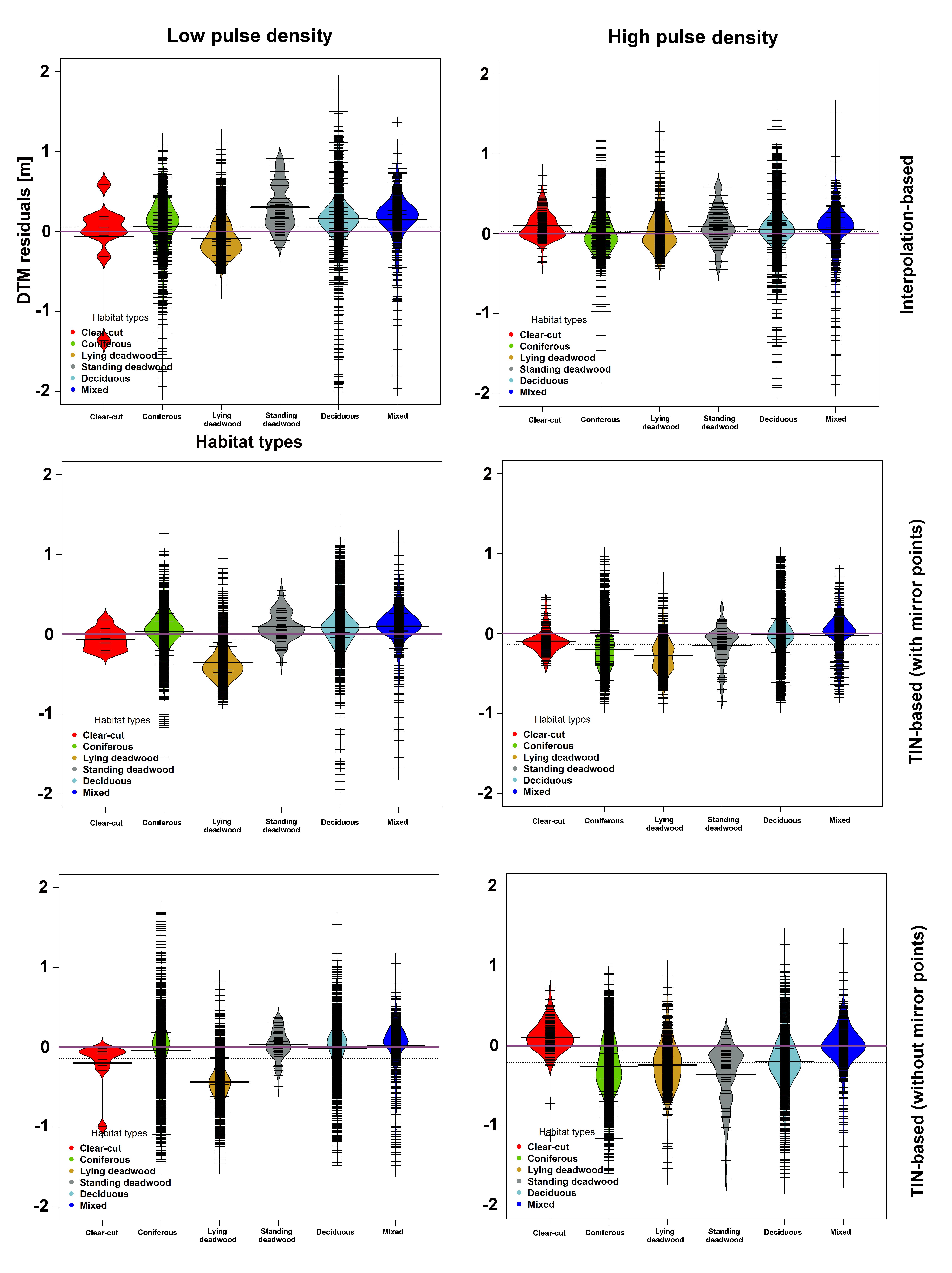
Impact of forest habitat types on residuals of DTMs extracted by interpolation- based (top row), adapted TIN based with mirror points (middle row), and adapted TIN based without mirror points (bottom row)

The results of a factorial analysis as ewll as a thorough validation of the quality of various DTM products within the Bavarian Forest National Park showed that topographic and forest habitat-type factors significantly contribute to the DTM accuracy, with pronounced efefcts observed mainly on south, southwest, and west slopes. Furthermore, an adaptive TIN ground-filtering algorithm with mirror points and followed by an interpolation-based algorithm contribute to comparatively lower errors on forest sites.

The full text can be retrieved here.

Aryal, R.R., Latifi, H., Heurich, M., Hahn, M. 2017. Impact of Slope, Aspect, and Habitat-Type on LiDAR-Derived Digital Terrain Models in a Near Natural, Heterogeneous Temperate Forest. PFG. DOI 10.1007/s41064-017-0023-2


you may also like:

Our research site and project covered by BR

Our research site and project covered by BR

The University forest at Sailershausen is a unique forest owned by the University of Wuerzburg. It comes with a high diversity of trees and most important is part of various research projects. We conducted various UAS/UAV/drone flights with Lidar, multispectral and...

Meeting of the FluBig Project Team

Meeting of the FluBig Project Team

During the last two days, the team of the FluBig project (remote-sensing.org/new-dfg-project-on-fluvial-research/) met at the EORC for discussing the ongoing work on fluvial biogeomorphology. After returning from a successful field expedition to Kyrgyzstan a couple of...

‘Super Test Site Würzburg’ project meeting

‘Super Test Site Würzburg’ project meeting

After the successful "Super Test Site Würzburg" measurement campaign in June (please see here: https://remote-sensing.org/super-test-site-wurzburg-from-the-idea-to-realization/ ), the core team from the University of Würzburg, the Karlsruhe Institute of Technology,...

EORC Talk: Geolingual Studies: A New Research Direction

EORC Talk: Geolingual Studies: A New Research Direction

On July 19th, Lisa Lehnen and Richard Lemoine Rodríguez, two postdoctoral researchers of the Geolingual Studies project, gave an inspiring presentation at the EORC talk series.   In the talk titled "Geolingual Studies – a new research direction", they...

EO support for UrbanPArt field work

EO support for UrbanPArt field work

From May to September, Karla Wenner, a PhD student at the Juniorprofessorship for Applied Biodiversity Science, will be sampling urban green spaces and semi-natural grasslands in Würzburg as part of the UrbanPArt project. Our cargo bikes support the research project...

Cinematic drone shots

Cinematic drone shots

We spend quite some time in the field conducting field work, from lidar measurements to vegetation samples in order to correlate it with remote sensing data to answer various research questions concerning global change. Field work is always a 24/7 work load and...