A new publication on “The urban morphology on our planet – Global perspectives from space” is available online in Remote Sensing of Environment. From the abstract: “
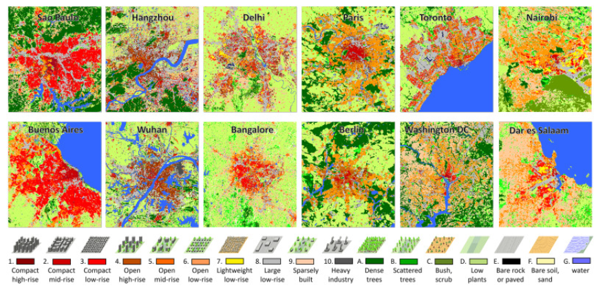
Urbanization is the second largest mega-trend right after climate change. Accurate measurements of urban morphological and demographic figures are at the core of many international endeavors to address issues of urbanization, such as the United Nations’ call for “Sustainable Cities and Communities”. In many countries – particularly developing countries –, however, this database does not yet exist. Here, we demonstrate a novel deep learning and big data analytics approach to fuse freely available global radar and multi-spectral satellite data, acquired by the Sentinel-1 and Sentinel-2 satellites. Via this approach, we created the first-ever global and quality controlled urban local climate zones classification covering all cities across the globe with a population greater than 300,000 and made it available to the community (https://doi.org/10.14459/2021mp1633461). Statistical analysis of the data quantifies a global inequality problem: approximately 40% of the area defined as compact or light/large low-rise accommodates about 60% of the total population, whereas approximately 30% of the area defined as sparsely built accommodates only about 10% of the total population. Beyond, patterns of urban morphology were discovered from the global classification map, confirming a morphologic relationship to the geographical region and related cultural heritage. We expect the open access of our dataset to encourage research on the global change process of urbanization, as a multidisciplinary crowd of researchers will use this baseline for spatial perspective in their work. In addition, it can serve as a unique dataset for stakeholders such as the United Nations to improve their spatial assessments of urbanization.”
read the full article at https://www.sciencedirect.com/science/article/pii/S0034425721005149?via%3Dihub