

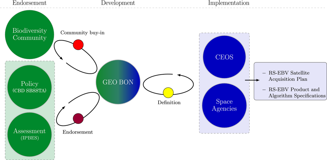
 Our new article on therole of space agencies in remotely sensed essential biodiversity variables is out in the newest Remote Sensing in Ecology and Conservation issue. From the abstract: “The Group on Earth Observations Biodiversity Observation Network (GEO BON) is developing the Essential Biodiversity Variables (EBVs) as the key variables needed, on a regular and global basis, to understand and monitor changes in the Earth’s biodiversity. A subset of these EBVs can be derived from space-based remote sensing, within this paper referred to as remotely sensed EBVs (RS-EBVs). Given the global, periodic and standardized character of satellite remote sensing measures, RS-EBVs may be seen as easier to generate than non-remotely sensed EBVs, which have to be assembled from disparate and local sources of information. Particularly because they are global and periodic, RS-EBVs are of special relevance for monitoring the state of and changes to biodiversity, notably the structure and function of ecosystems. If well developed, RS-EBVs can provide key information for global biodiversity assessments as well as for national governments to meet their obligations under the Convention on Biological Diversity (CBD), in particular to formulate and implement appropriate management responses to biodiversity losses. However, the relevance and usage of globally produced RS-EBVs in wide-scale ecological modelling, such as in species distribution and abundance studies or in ecosystem integrity analyses, are still to be demonstrated, in particular when it comes to deriving biodiversity indicators for policy making and implementation. The biodiversity community at large, from those conducting scientific ecological studies to those involved in the development of remote sensing applications for biodiversity monitoring, can gain value from RS-EBVs, but doing so requires close cooperation with space agencies. Effective interaction is only likely to result if the biodiversity community understands how space agencies determine their observation and product requirements. To develop these requirements, space agencies need to precisely specify the physical measurements for their spaceflight instruments, as well as the algorithmic approaches, to generate RS-EBV products from these measurements. Here, we address the biodiversity community to discuss the role space agencies should play in the development of EBVs arising from satellite remote sensing. Importantly, we explain the necessity for translating the observational needs of the biodiversity community into specific satellite remote sensing measurement and algorithm requirements. By summarizing the prerequisite conditions that are required for obtaining a collective and strong engagement of space agencies in the co-development of RS-EBVs, we aim to facilitate collaborative efforts between the biodiversity community and the space agencies, which can ultimately contribute to a global and comprehensive biodiversity knowledge system.”


