đź—ş Exploring Map Visualizations

đź—ş Exploring Map Visualizations

m


July 11, 2025

Within our EAGLE courses our students have to learn a wide variety of skills – beside the fundamental earth observation theory and practice also skills like map creation is part of the curriculum. One of our students Ronja Seitz has created three visualizations guides that highlight different aspects of geospatial data presentation. Each map is built using a distinct R-based technique, tailored to specific communication needs—from interactive exploration to 3D topography and publication-ready maps.


1. Interactive Location Map with Leaflet

This map uses the Leaflet library in R to provide an interactive interface where users can:

  • Pan and zoom freely

  • Click on markers for site-specific information

  • View basemaps with OpenStreetMap tiles

Technical stack:

  • leaflet, htmlwidgets, sf

  • Vector layers for site markers

  • HTML integration for interactivity

Ideal for: Web-based exploration and public-facing project communication.


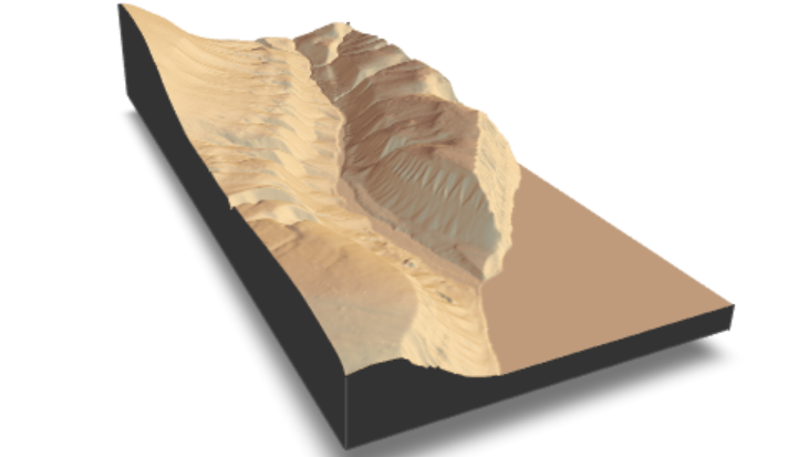
2. 3D Terrain Visualization with Rayshader

This visualization renders a 3D perspective map of the landscape using the rayshader package. It enhances spatial understanding through:

  • Elevation shading and depth

  • High-resolution terrain rendering

  • View angles and lighting to simulate real topography

Technical stack:

  • rayshader, elevatr, rgl, raster

  • Digital Elevation Model (DEM) input

  • Custom camera angle and z-scale tuning

Ideal for: Terrain interpretation and presentations requiring visual impact.


3. Area of Interest (AOI) Map with ggplot2

This clean, static map is made using ggplot2 and sf, emphasizing clarity and aesthetics. It displays the AOI with:

  • Precise boundary delineation

  • Scalable vector-based output

  • Muted basemaps and intuitive labeling

Technical stack:

  • ggplot2, sf, rnaturalearth, ggspatial

  • High-resolution output formats (PDF, PNG)

Ideal for: Scientific publications, posters, or reports.


🎯 Why it matters:

These three maps reflect Ronja’s thoughtful approach to visual storytelling in geospatial science. By leveraging different R packages, each map meets a different communication need—interactive web content, immersive 3D insight, or crisp print-quality graphics.

Explore the full project:  Website by Ronja Seitz

you may also like:

Exploring the Desert: Farimah’s Internship at Gobabeb in Namibia

Exploring the Desert: Farimah’s Internship at Gobabeb in Namibia

We’re excited to share that our EAGLE MSc student, Farimah, is currently spending her internship at the renowned Gobabeb Namib Research Institute, nestled in the heart of the Namib Desert—one of the oldest and most unique desert ecosystems in the world. Farimah’s...

Field Impressions from the Beech Decline Survey

Field Impressions from the Beech Decline Survey

In late July, PhD student Julia Rieder and EAGLE student Henning Riecken (InnoLab) conducted field visits to several beech forest stands in Northern Bavaria. Their survey covered regions including the Rhön, the Steigerwald, and areas around Würzburg and Bayreuth, as...

EAGLE Advanced Course in Applied Programming for Urban Studies

EAGLE Advanced Course in Applied Programming for Urban Studies

Our EAGLE students recently wrapped up the Applied Programming for Urban course by our PhD student De-Cyuan Jheng — a hands-on, advanced continuation of last semester’s Spatial Python for Remote Sensing. Building on their foundational skills, this course further...

Summer Vibes, Science, and Socials: Our BBQ Event 2025!

Summer Vibes, Science, and Socials: Our BBQ Event 2025!

What happens when science meets grilled goodness and great company? A perfect summer evening — and that's exactly what we had at our annual Summer BBQ on July 24th! Kicking off at 4 pm under surprisingly sunny skies and a relaxed atmosphere, this year’s event blended...

Successful PhD defense by Adomas Liepa

Successful PhD defense by Adomas Liepa

We’re happy to announce that our PhD student Adomas Liepa has successfully defended his doctoral thesis, titled “Potential of Satellite Earth Observation in Seasonal Monitoring of Complex Agricultural Environments of East Africa”, on Thursday, July 24th at 11:00 AM....

Successful PhD defense by Thilo Erbertseder

Successful PhD defense by Thilo Erbertseder

We congratulate Thilo Erbertseder from the Earth Observation Center (EOC) of the German Aerospace Center (DLR) on his successful defense of his PhD thesis. The thesis is titled “Satelliten-basierte Analyse der Luftverschmutzung durch Stickstoffdioxid: von globalen zu...

Privacy Policy

Lehrstuhl fĂĽr Fernerkundung & Lehrstuhl fĂĽr Urbane Fernerkundung

Erdbeobachtung an der Universität Würzburg