new publication: Mapping Bushmeat Hunting Pressure in Central Africa

new publication: Mapping Bushmeat Hunting Pressure in Central Africa

February 1, 2016

Biotropica_Ziegler_Fa_Wegmann_bushmeat_hunting_pressure_2016

Hunting pressure modelled for Central Africa (Biotropica link)

Our analysis on mapping bushmeat hunting pressure in Africa based on various co-variates, such as land cover, is now available online. Is is related to our article in NATURE Scientific Reports.

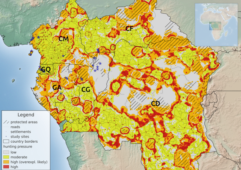
Hunting and trade of wild animals for their meat (bushmeat), especially mammals, is commonplace in tropical forests worldwide. In West and Central Africa, bushmeat extraction has increased substantially during recent decades. Currently, such levels of hunting pose a major threat to native wildlife. In this paper, we compiled published data on hunting offtake of mammals, from a number of studies conducted between 1990 and 2007 in Cameroon, Central African Republic, Democratic Republic of Congo, Equatorial Guinea, Gabon, and Republic of Congo. From these data sources, we estimated annual extraction rates of all hunted species and analyzed the relationship between environmental and anthropogenic variables surrounding each hunting rate and levels of bushmeat extraction. We defined hunting pressure as a function of bushmeat offtake and number of hunted species and confirm that hunting pressure is significantly correlated with road density, distance to protected areas and population density. These correlations are then used to map hunting pressure across the Congo Basin. We show that predicted risk areas show a patchy distribution throughout the study region and that many protected areas are located in high-risk areas. We suggest that such a map can be used to identify areas of greatest impact of hunting to guide large-scale conservation planning initiatives for central Africa.


Stefan Ziegler, John E. Fa, Christian Wohlfart, Bruno Streit,Stefanie Jacob and Martin Wegmann (2016) Mapping Bushmeat Hunting Pressure in Central Africa. Biotropica. http://onlinelibrary.wiley.com/doi/10.1111/btp.12286/abstract

you may also like:

🗺 Exploring Map Visualizations

🗺 Exploring Map Visualizations

Within our EAGLE courses our students have to learn a wide variety of skills - beside the fundamental earth observation theory and practice also skills like map creation is part of the curriculum. One of our students Ronja Seitz has created three visualizations guides...

Successful Completion of UNIversInternational Certificate

Successful Completion of UNIversInternational Certificate

In line with its internationalization strategy, the University of Würzburg supports administrative staff in their task of advising and supporting international students, guests, and academics. To this end, it has launched the "UNIversInternational" certificate...

The “Geolingual Studies” team visited the DLR EOC

The “Geolingual Studies” team visited the DLR EOC

The "Geolingual Studies" team of the University Würzburg visited the DLR-EOC on 3 and 4 July 2025. Geolingual Studies is an innovative area of research and teaching which takes a decisively applied linguistic approach and combines methodologies from linguistics,...

Course on Object-based image analysis

Course on Object-based image analysis

Dr. Michael Wurm from the German Aerospace Center (DLR) gave a class about Object-based image analysis (OBIA) using the eCognition Software for the EAGLE students. The course gives an insight into the theoretical basis of OBIA and using different datasets and tasks...