New publication: Further progress in model-based estimation of forest understorey by LiDAR data

New publication: Further progress in model-based estimation of forest understorey by LiDAR data

January 27, 2017

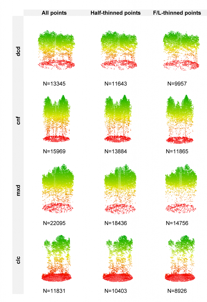
In a recently-published paper in Forestry featuring Hooman Latifi, Steven Hill and Stefan Dech from the Dept. of Remote Sensing, further advancements have been reported in developing unbiased statistical models for area-based estimation of forest understorey layers using LiDAR point cloud information. The study leveraged an original high-density LiDAR point cloud, which was further processed to simulate two lower-density datasets by applying a thining approach. The data were then combnined with three statistical modeling approaches to estimate the proportions of shrub, herb and moss layers in temperate forest stands in southeastern Germany.


Despite the differences between our simulated data and the real-world LiDAR point clouds
of different point densities, the results of this study are thought to mostly reflect how LiDAR and forest habitat data can be combined for deriving ecologically relevant information on temperate forest understorey vegetation layers. This, in turn, increases the applicability of prediction results for overarching aims such as forest and wildlife management.

Further informaiton on the published paper can be retrieved here.

Bibliography:

Latifi, H., Hill, S., Schumann, B., Heurich, M., Dech, S. 2017. Multi-model estimation of understorey shrub, herb and moss cover in temperate forest stands by laser scanner data. Forestry, DOI:10.1093/forestry/cpw066


you may also like:

Bridging Scales: How Radar Satellites supports Crop Monitoring

Bridging Scales: How Radar Satellites supports Crop Monitoring

In an era of climate uncertainty and increasing pressure on agricultural systems, understanding how crops grow and respond to environmental stress is more important than ever. A new study led by researchers from Martin-Luther-University Halle-Wittenberg, in close...

New paper on automated pollinator monitoring using time-lapse images

New paper on automated pollinator monitoring using time-lapse images

Researchers from Helmholtz Centre for Environmental Research (UFZ) in Leipzig, the German Centre for Integrative Biodiversity Research (iDiv) in Leipzig, the Martin Luther University Halle-Wittenberg, the German Remote Sensing Data Center (DFD) of the German Aerospace...

Media reporting on “understanding urban heat in Germany”

Media reporting on “understanding urban heat in Germany”

We recently reported on the urban heat island effect in Germany and the work of DLR and EORC on the topic – please see here: https://remote-sensing.org/understanding-urban-heat-in-germany-insights-from-prof-hannes-taubenbocks-research/   Here is a link to...

Proceedings of JURSE published

Proceedings of JURSE published

Our EORC and our colleagues from DLR have contributed with various research works to the Joint Urban Remote Sensing Event (JURSE) 2025. This bi-annual conference took place in Tunis, Tunisia, in early May 2025. JURSE is committed to introduce innovative methodologies...