Workshop Report at the Department of Remote Sensing – November 27, 2019

Workshop Report at the Department of Remote Sensing – November 27, 2019

m

November 13, 2019

We are glad to announcing our next workshop at the Department of Remote Sensing for Wednesday, 27th November 2019.

The presentation will be about

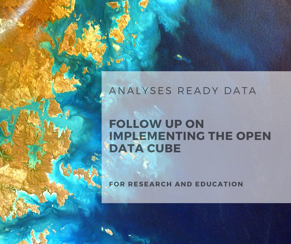
Analyses Ready Data – Follow‐up on Implementing the Open Data Cube for Research and Education

Abstract

Analyses ready data (ARD) are on the way forward to provide multi-sensor satellite data for different applications. However, the integration of ARD process chains and interfaces into image analyses frameworks is still challenging for academic, commercial and public organizations. The Open Data Cube (ODC) software provides a framework to automate Earth Observation (EO) data pre-processing and interfaces for developers and users. Currently, we are operating two data cubes using the ODC software at the Remote Sensing Department hosted at the Leibniz Supercomputing Centre (LRZ) of the Bavarian Academy of Sciences and Humanities in Garching.
The presentation will provide an update of the recent developments on implementing disruptive technologies on cloud-based EO data management and ARD data provision for in-house research activities as well as R&D projects.

Title of presentation: Analyses Ready Data – Follow-up on Implementing the Open Data Cube for Research and Education

Presenter: Christian Hüttich, Department of Remote Sensing, University of Würzburg

Date: Wednesday, 27th November Time: 10 – 11:00 am s.t. Place: Josef-Martin-Weg 52 (1), Campus Hubland Nord, Würzburg

Presentation language: English Slides: English

All interested persons are cordially invited! We are looking forward to seeing you.

follow us and share it on:

you may also like:

Seeing the World in Points: Lidar Course for the EAGLEs

Seeing the World in Points: Lidar Course for the EAGLEs

Lidar has a funny way of sneaking up on you. You think you know what it is, a laser that measures distance, fine, but then someone shows you a point cloud of a forest canopy with individual branches floating in 3D space and suddenly you realize there's a whole...

RTL covers EORC: TV Crew Films MONID Habitrack Fieldwork

RTL covers EORC: TV Crew Films MONID Habitrack Fieldwork

A bit of extra excitement at EORC recently, an RTL television crew showed up to film a segment on the MONID Habitrack project, and Dr. Ariane Droin was right in the middle of it, walking them through what Earth Observation actually brings to the table for a project...

Ticks from Above: UAS Fieldwork for the MONID Habitrack Project

Ticks from Above: UAS Fieldwork for the MONID Habitrack Project

Forest edges are tricky places. They're where woodland meets open ground, where light and shade trade off every few meters, and where, it turns out, ticks tend to do really well. That last bit is exactly why Dr. Ariane Droin, Sofica Garcia de Leon, Dr. Jakob...

Course on urban EO by Michael Wurm

Course on urban EO by Michael Wurm

Walk through any city and you pick up on things that are hard to put a number on. The noise of a main road, the heat that sits between buildings in summer, the question of whether that little park around the corner is really enough green space for the whole...

EireR R package: unified gateway to Irish geospatial data

EireR R package: unified gateway to Irish geospatial data

Anyone who's tried to do geospatial work across the whole island of Ireland knows the headache. Ireland is one island geographically, but it's split across two jurisdictions, the Republic and Northern Ireland, and each one runs its own data infrastructure. Different...

Impact of agrophotovoltaic facilities – an R package

Impact of agrophotovoltaic facilities – an R package

There's a new R package on the block, and it's solving a problem that sounds simple until you actually try to do it: how do you tell whether putting solar panels over a farm field is good or bad for the soil and the crops around them? Marlene, one of our EAGLE...

Share This