Ph.D. student was awarded for his short talk and poster during the EGU Galileo Conference “Fire impacts at the Earth Surface Across space and time”

Ph.D. student was awarded for his short talk and poster during the EGU Galileo Conference “Fire impacts at the Earth Surface Across space and time”

April 4, 2022

Boris Ouattara (Physical Geography and part of the WASCAL-DE-Coop project) presented his research on West African vegetation fire and its induced emission at the EGU Galileo Conference “Fire impacts at the Earth surface across space and time: perspectives for future fire management”. This conference was held in Bad Belzig, Germany, from 28th of March to 1st of April 2022, and aimed at providing a discussion-driven meeting to facilitate knowledge transfer between fire science disciplines and to identify research needs to support fire management in the future.

Boris Ouattara in front of his research poster at the EGU Galileo Conference “Fire impacts at the Earth surface across space and time: perspectives for future fire management”

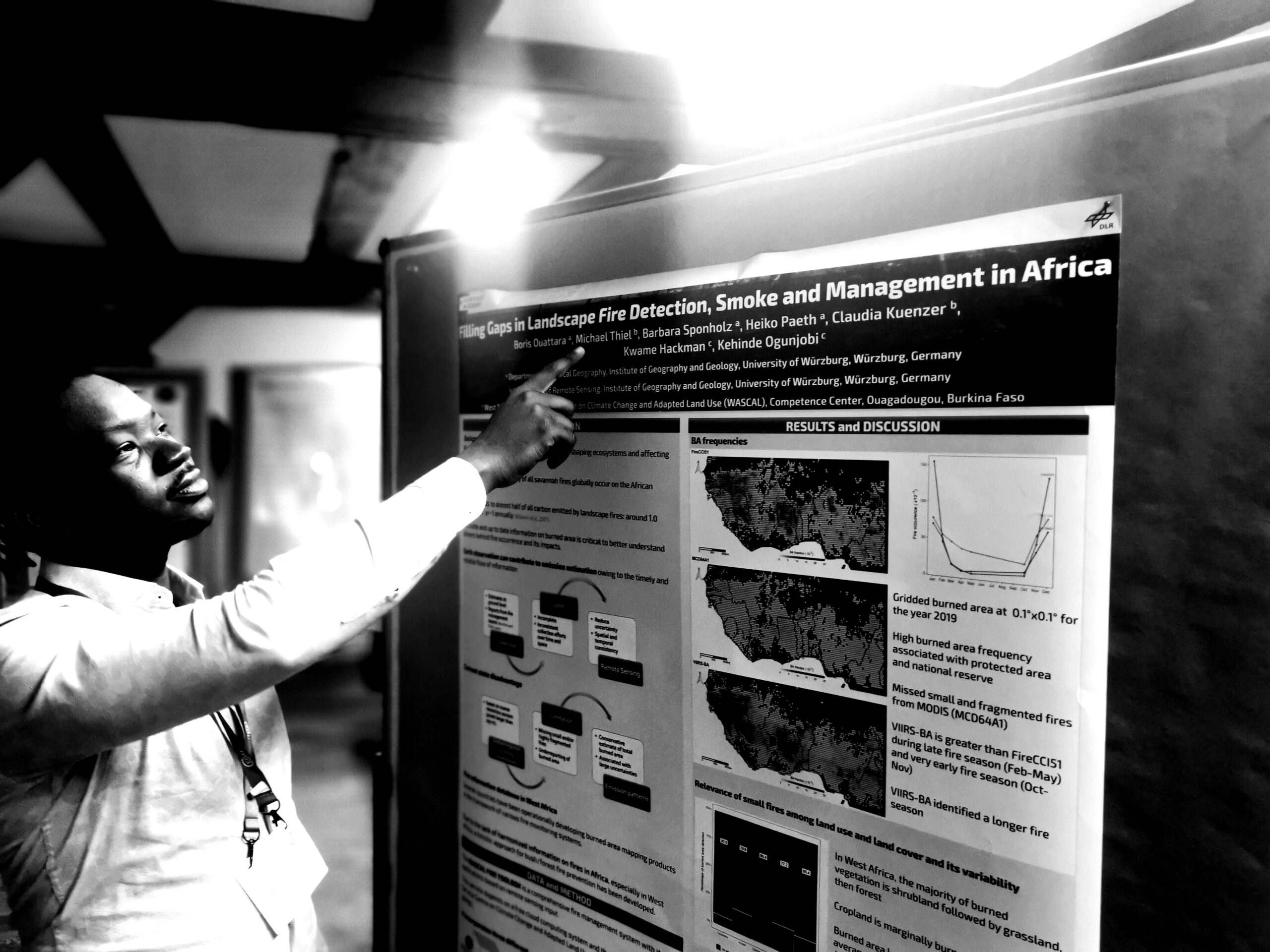
Boris presented on the WASCAL Fire Toolbox aiming at Filling Gaps in Landscape Fire Detection, Smoke, and Management in Africa. With his study conducted in the context of the BMBF-funded WASCAL-DE-Coop project, Boris contributes to the scientific landscape of WASCAL in West Africa.

We congratulate him on being awarded the best Ph.D. candidate presentation for the Early Career Scientists short talk and poster competition.

follow us and share it on:

you may also like:

How We Learned to Fly: The Story Behind UAS Research at EORC

How We Learned to Fly: The Story Behind UAS Research at EORC

Every research group that's ever bought a drone has a story about the first one it lost. We're no different. So let's just get that out of the way up front: this is the inside story of how UAS (Unoccupied Aerial System) research grew up at the Earth Observation...

MainPro workshop on TLS and LiDAR UAS

MainPro workshop on TLS and LiDAR UAS

This week, a workshop organized by Sebastian Buchelt within our EFRE project MainPro brought together students, researchers, and interested project partners to explore modern UAV technologies. The workshop took place in vineyards close to Würzburg and gave the...

25 Years of Remote Sensing in Würzburg

25 Years of Remote Sensing in Würzburg

Our chair of remote sensing, Professor Stefan Dech, likes to say "science is rarely a sprint, it's a marathon". And if you look at what's grown out of Würzburg over the last 25 years, you'll see exactly what he means. In 2026 the Julius-Maximilians-Universität...

Starkregen in Bayern: Beobachtungen und Dokumentation zählen

Starkregen in Bayern: Beobachtungen und Dokumentation zählen

Starkregenereignisse treten immer häufiger lokal, kurzfristig und mit hoher Intensität auf. Innerhalb weniger Stunden können sie erhebliche Überschwemmungen und Schäden verursachen. Um solche Ereignisse künftig besser zu verstehen und die wissenschaftliche Grundlage...

Seeing the World in Points: Lidar Course for the EAGLEs

Seeing the World in Points: Lidar Course for the EAGLEs

Lidar has a funny way of sneaking up on you. You think you know what it is, a laser that measures distance, fine, but then someone shows you a point cloud of a forest canopy with individual branches floating in 3D space and suddenly you realize there's a whole...

TV Crew Films EORC at MONID Habitrack Fieldwork

TV Crew Films EORC at MONID Habitrack Fieldwork

A bit of extra excitement at EORC recently: A television crew showed up to film a segment on the MONID Habitrack project financed by the BMFTR, and Dr. Ariane Droin was right in the middle of it, walking them through what Earth...

Share This