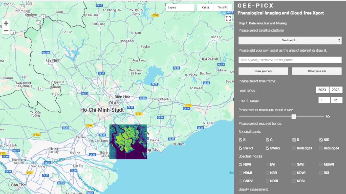
Our PhD student Luisa Pflumm published an article on “GEE-PICX: generating cloud-free Sentinel-2 and Landsat image composites and spectral indices for custom areas and time frames – a Google Earth Engine web application.” in Ecography. Check out the contente here from the abstract: “Earth observation satellites are collecting vast amounts of free and openly accessible data with immense potential to support environmental, economic, and social fields. As the availability of remotely sensed data increases, so do the methods for accessing and processing it. Many solutions exist for creating cloud-free image composites from often cloudy satellite data, but these typically require coding skills or in-depth training in remote-sensing techniques. This technical barrier prevents many researchers and practitioners from utilising available satellite data. The few user-friendly solutions that exist often have limitations in terms of data export size and quality assessment capabilities. We developed GEE-PICX, a web application with an intuitive graphical user interface on the cloud computing platform Google Earth Engine. This tool addresses the aforementioned challenges by creating cloud-free, analysis-ready image composites for user-defined areas and time periods. It utilises Sentinel-2 and Landsat 5, 7, 8, and 9 images and offers global coverage. Users can aggregate image composites annually or seasonally, with data availability starting from 1984 (the launch of Landsat 5). The workflow automatically filters all available satellite data according to user input, removing clouds, cloud shadows, and snow. It provides spectral band information, calculates various thematic spectral indices (including vegetation, burn, built-up area, bare soil, snow, moisture, and water indices), and includes a quality assessment band indicating the number of valid scenes per pixel. GEE-PICX offers a customizable tool for creating custom data products from freely accessible satellite data, catering to researchers with limited remote sensing experience. It provides extensive temporal and global spatial coverage, with server-side processing eliminating hardware constraints. The tool facilitates easy export of time series as ready-to-use rasters with numerous spectral indices, supporting environmental programmes and biodiversity research across various disciplines.”
and read the full article here: nsojournals.onlinelibrary.wiley.com/doi/10.1111/ecog.07385
and read the full article here: nsojournals.onlinelibrary.wiley.com/doi/10.1111/ecog.07385