In situ and radar-based assessment and analysis of the surface soil moisture and its dynamic in the agrarian landscape in South Italy
Objective Semi-arid to arid climate determines the natural water availability in the Mediterranean. In particular, groundwater reservoirs are the main source of freshwater in the Mediterranean region. Climate change as well as increasing water consumption in irrigated agriculture are identified as major drivers of increasing groundwater scarcity and overuse of fragile groundwater resources. The aim of the joint project MedWater within the BMBF-funded GRoW initiative is to improve the dynamic risk assessment of those factors affecting the groundwater recharge. By means of process-based prediction models and under consideration of the climatic variability and hydrology, the water flows and the soil moisture as well as the processes in the soil and their feedback with the vegetation are to be modelled in high spatial and temporal resolutions and simulated for different scenarios of use.
The envisaged master thesis aims at gathering and analyzing in-situ and radar-based (Sentinel-1) surface soil moisture as an essential input parameter for describing model boundary conditions. The spatial focus of the fieldwork to be carried out lies on a small (approximately 30 ha) agricultural study area in the Upper Alento River Catchment in the south of Italy. The analysis also focuses on the spatial-temporal variability of surface soil moisture and its significance as areal input data for the parameterization of hydrological models.
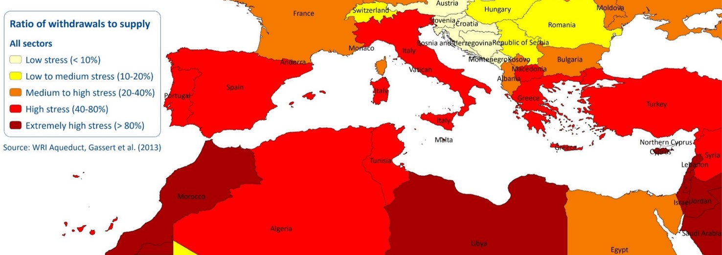
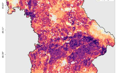
Figure Water stress in the Mediterranean. Source: WIR Aqueduct, Gassert et al. (2013).
Point of Contact Dr. Sarah Schönbrodt-Stitt (sarah.schoenbrodt-stitt@uni-wuerzburg.de), Dr. Nima Ahmadian (nima.ahmadian@uni-wuerzburg.de), Department of Remote Sensing, Institute of Geography, University of Würzburg
Requirements B.Sc. degree or almost completed MSc study in the field of geographic remote sensing, geography, soil science, hydrology or comparable, interest and / or previous knowledge in fieldwork and in dealing with measuring sensors, interest in hydrological topics, previous knowledge in the field of remote sensing, knowledge in spatial statistics and geoinformation systems
Workplace fieldwork (2-3 weeks) in the study area (Upper Alento River, province of Salerno) in Italy. Otherwise, the place of work outside the fieldwork is freely selectable. Regular meetings with the supervisor and a presentation of the subject are mandatory
Contact Dr. Sarah Schönbrodt-Stitt / Department of Remote Sensing / Institute of Geography and Geology / University of Würzburg / Phone +49 (0) 931 31 83300 / E-mail sarah.schoenbrodt-stitt@uni-wuerzburg.de / https://www.geographie.uni-wuerzburg.de/en/fernerkundung/startseite/