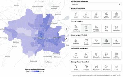
Data on urban trees in Munich contribute to the current debate on climate change adaptation
Based on a recent study conducted by researchers from the German Remote Sensing Data Center (DFD) of the German Aerospace Center (DLR) and the Earth Observation Research Cluster of the Julius-Maximilians-University, the urban tree stock of Munich was comprehensively quantified based on remote sensing data (please see a paper titled “Urban Trees in Munich – Detection, Delineation, Quantification, and Characterization based on VHR Remote Sensing data” – https://repository.corp.at/829/). In total, we found 1.54 million trees in Munich with its crowns covering an area of 92.8 km² corresponding to about 30% of the entire city area.
However, this value naturally varies per city district from around 16% in the city center up to more than 40% in the peripheral districts of Munich. In relation to climate change adaptation on the municipal level, the German Federation for the Environment and Nature Conservation (BUND Naturschutz) published a press release based on our data in order to contribute to the current public debate (https://bn-muenchen.de/muenchens-hitze-zukunft-jetzt-entscheiden/).
Please find more of our research studies related to urban green here:
- Spatially-optimized urban greening for reduction of population exposure to land surface temperature extremes – https://www.nature.com/articles/s41467-023-38596-1
- Does urbanization mean a loss of greenspace? A multi-temporal analysis for Chinese cities – https://www.sciencedirect.com/science/article/abs/pii/S0048969723049987
- Green cities cost more green: Examining the impacts of different urban expansion patterns on NPP – https://www.sciencedirect.com/science/article/abs/pii/S0360132322011064
- Which city is the greenest? A multi-dimensional deconstruction of city rankings – https://www.sciencedirect.com/science/article/pii/S0198971521000946