We’ve recently started an exciting research project focused on mapping steep rock slopes that contain valuable paleontological information. Unlike most drone surveys that focus on horizontal ground surfaces, our work is aimed vertically—capturing data along exposed cliff faces where ancient layers of rock are visible.
To do this, we’re using drones equipped with multispectral, hyperspectral, and LiDAR sensors. These tools allow us to collect detailed data about the surface composition and structure of the rock slopes. Our aim is to better understand the geological context of fossil-bearing layers and how they vary across these vertical exposures.
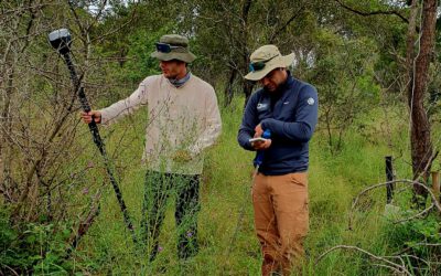
Fieldwork is also an essential part of the project. In order to verify and support the drone data, members of our team—including staff and students—will carry out field measurements directly on the rock face. This means safely lowering themselves onto the steep slopes to collect spectral data by hand. Thanks to our local bouldering gym “Rock In” are we able to test our setup for lowering some of our researchers down the cliff for collecting field data – checking redundant safety approaches and applicability with the sensor equipment is important for the success of our project.
By combining remote sensing and hands-on fieldwork, we hope to improve our understanding of the paleontological record preserved in these challenging, yet scientifically rich environments.