new article: Measuring β-diversity by remote sensing: a challenge for biodiversity monitoring

new article: Measuring β-diversity by remote sensing: a challenge for biodiversity monitoring

February 1, 2018

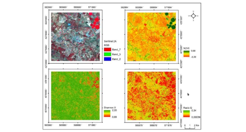
Another article lead by Duccio Rocchini was published on “Measuring β-diversity by remote sensing: a challenge for biodiversity monitoring” in Methods in Ecology and Evolution. Collecting field data is difficult, especially when aiming at modelling biodiversity changes in space and time. This would assume statistically sound sampling schemes. Airborne or satellite remote sensing provide data over large areas, however many biodiversity maps obtained from earth observation have been based on the inference of species richness by regression analysis. Estimating compositional turnover (β-diversity) might add crucial information related to relative abundance of different species instead of just richness. This approach is further discussed in this article. The full article can be read in Methods in Ecology and Evolution.

Rocchini, D, Luque, S, Pettorelli, N et al. (2017) Measuring β-diversity by remote sensing: a challenge for biodiversity monitoring. Methods in Ecology and Evolution. ISSN 2041-210X (In Press)

you may also like:

Successful Master’s thesis defense by Prince Lartey Lawson

Successful Master’s thesis defense by Prince Lartey Lawson

Our EAGLE Prince Lartey Lawson successfully defended his Master's thesis today (April 30th) titled "" Unmasking the Shadow Economy in Ghana: Mapping the Distribution of Umbrella Covered Informal Vendors In Kumasi". From the abstract of his thesis: Informal trade in...

Spatial Earth Observation R packages by our EAGLEs

Spatial Earth Observation R packages by our EAGLEs

Our EAGLE students that took and passed our Introduction to spatial programming course had to submit an R package that applies spatial methods for a variety of Earth Observation data. We are very proud to show the huge diversity of very interesting and useful R...

cooperative project with DLR ZKI

cooperative project with DLR ZKI

In cooperation with the DLR ZKI did we conduct drone flights last week using Lidar and oblique sensors in order to provide valuable landscape information for autonomous vehicle navigation. Within the project the feasibility to map unknown areas and its accessibility...

Object oriented image classification course

Object oriented image classification course

Today our EAGLE object based image analysis (OBIA) started, taught by our colleague Dr Michael Wurm, team leader at the DLR Earth Observation center GZS department.  Michael is covering the theory and practice of OBIA in his class and thereby broadening the...