We tried to go one step further to quantify northern latitude vegetation trends. This paper on modelling the arctic taiga-tundra ecotone using ALOS PALSAR and optical #earthobservation data was published two months ago.
Find the paper here: https://doi.org/10.1016/j.jag.2019.05.008
Abstract:
The taiga-tundra ecotone (TTE) extends over 13.400 km around the northern hemisphere and marks the transition
zone between taiga and tundra. Since this area is vulnerable to climate change, human activities and
natural disturbances such as wildfires, monitoring of this region is extremely important. Dealing with the
characterization of this transition zone, very few studies are available on a global scale. Existing approaches lack
the thorough characterization of the ecotone as they capture just a part of the complex transition zone.
The objective of this research is to develop a monitoring concept for detecting the taiga-tundra interface for a
designated study area in northern Siberia. We used optical and SAR remote sensing data products from 2007 to
2010, whereby the spatial resolution of all datasets were unified to 1 km. Earth Observation data and products
from ALOS PALSAR, MODIS, AMSR-E were utilized in addition to digital elevation model data and the Percent
Tree Cover product. Using random forest variable importance measure, most relevant statistics were selected and
used for different model setups. The final random forest model setup included statistics of land surface temperature
(LST), albedo, NDVI, EVI, Vegetation Continuous Fields (VCF), PALSAR HV-Polarization and LAI. Snow
water equivalent (SWE) statistics had to be excluded for compensating artifacts.
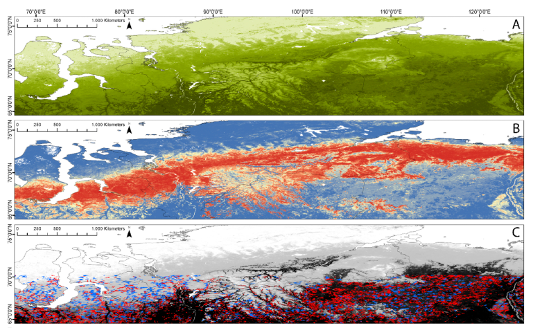
Since sharp distinctions between forest and tundra do not occur in nature, class probability values were
computed. This allowed the unique allocation per class for each grid cell. The model setup showed high performance
values, which were cross validated, with accuracies of 95.6% (±1.5%). The model result was validated
using high resolution Google Earth imagery, where an overall map accuracy of 93% (Kappa 0.89) was
achieved. The assessment of the input data products revealed that statistics of LST, SWE and albedo were most
important.
Compared to existing circumpolar products the advantage of this approach is the derivation of continuous
probability values for the taiga-tundra transition zone instead of sharp borders between the biogeographic
classes. The model provides the basis for a monitoring effort aiming at detecting changes over time. This would
help to understand the dynamics of ecosystem changes with respect to influencing factors.