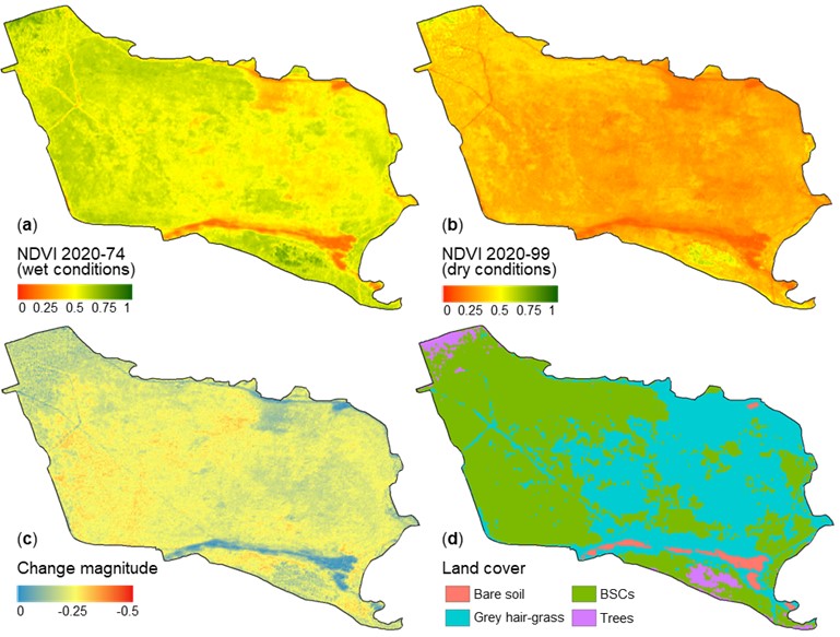
We are glad to share with you our newest publication on “Coverage and Rainfall Response of Biological Soil Crusts Using Multi-Temporal Sentinel-2 Data in a Central European Temperate Dry Acid Grassland” in the open-access journal Remote Sensing by MDPI. We congratulate Jakob Rieser as the first author for this great achievement. The authors of the publication are Jakob Rieser, Maik Veste (Institute of Environmental Sciences, Brandenburg University of Technology Cottbus-Senftenberg), Michael Thiel, and Sarah Schönbrodt-Stitt.
From the abstract: Biological soil crusts (BSCs) are thin microbiological vegetation layers that naturally develop in unfavorable higher plant conditions (i.e., low precipitation rates and high temperatures) in global drylands. They consist of poikilohydric organisms capable of adjusting their metabolic activities depending on the water availability. However, they, and with them, their ecosystem functions, are endangered by climate change and land-use intensification. Remote sensing (RS)-based studies estimated the BSC cover in global drylands through various multispectral indices, and few of them correlated the BSCs’ activity response to rainfall. However, the allocation of BSCs is not limited to drylands only as there are areas beyond where smaller patches have developed under intense human impact and frequent disturbance. Yet, those areas were not addressed in RS-based studies, raising the question of whether the methods developed in extensive drylands can be transferred easily. Our temperate climate study area, the ‘Lieberoser Heide’ in northeastern Germany, is home to the country’s largest BSC-covered area. We applied a Random Forest (RF) classification model incorporating multispectral Sentinel-2 (S2) data, indices derived from them, and topographic information to spatiotemporally map the BSC cover for the first time in Central Europe. We further monitored the BSC response to rainfall events over a period of around five years (June 2015 to end of December 2020). Therefore, we combined datasets of gridded NDVI as a measure of photosynthetic activity with daily precipitation data and conducted a change detection analysis. With an overall accuracy of 98.9%, our classification proved satisfactory. Detected changes in BSC activity between dry and wet conditions were found to be significant. Our study emphasizes a high transferability of established methods from extensive drylands to BSC-covered areas in the temperate climate. Therefore, we consider our study to provide essential impulses so that RS-based biocrust mapping in the future will be applied beyond the global drylands.
Full article: Rieser, J.; Veste, M.; Thiel, M.; Schönbrodt-Stitt, S. Coverage and Rainfall Response of Biological Soil Crusts Using Multi-Temporal Sentinel-2 Data in a Central European Temperate Dry Acid Grassland. Remote Sensing 2021, 13(16), 3093, https://doi.org/10.3390/rs13163093


