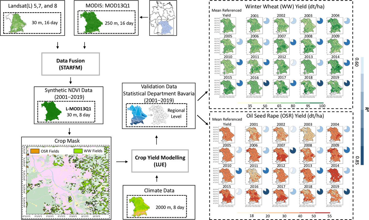
We are excited to share an innovative publication (https://www.mdpi.com/2072-4292/15/6/1651/pdf), “Impact of STARFM on Crop Yield Predictions: Fusing MODIS with Landsat 5, 7, and 8 NDVIs in Bavaria Germany”, which highlights the potential of the Spatial and Temporal Adaptive Reflectance Fusion Model (STARFM) to improve crop yield prediction accuracy.
The research accessed the remote sensing data from Landsat 5, 7, and 8 satellites and the Moderate Resolution Imaging Spectroradiometer (MODIS) to develop a methodology that utilizes the strengths of each dataset. Fusing these data sets allowed to create high-quality Normalized Difference Vegetation Index (NDVI) maps to predict crop yields.
The study’s findings suggest that using STARFM to combine MODIS and Landsat NDVI data significantly improved crop yield predictions compared to using either dataset alone. The approach was particularly effective in areas with high cloud and shadow cover, making obtaining reliable data from individual satellites difficult.
This study has important implications for farmers, policymakers, and researchers who rely on accurate crop yield predictions to plan and make decisions. By providing a more precise forecast of crop yields, farmers can make better-informed decisions about when to harvest, how much to plant, and how to allocate resources such as water and fertilizer. Policymakers can use this information to make food security and resource management decisions, while researchers can use it to further refine and improve crop yield prediction models.
We recommend this article to anyone interested in this area of research, and we are confident that it will generate significant interest and discussion among geographers and other professionals.
The manuscript is authored by Maninder Singh Dhillon, Thorsten Dahms, Carina Kübert-Flock (Hlnug, Wiesbaden), Adomas Liepa, Thomas Rummler (Uni Augsburg), Joel Arnault (KIT Garmisch-Partenkirchen), Ingolf Steffan-Dewenter and Tobias Ullmann.
Link to the manuscript: https://www.mdpi.com/2072-4292/15/6/1651


