New paper by Hannes Taubenböck and team titled “Mapping of small water bodies with integrated spatial information for time series images of optical remote sensing”.
https://www.sciencedirect.com/science/article/pii/S0022169422011507?dgcid=author
Abstract: Small water bodies and their temporal changes are, especially in urban areas, closely related to people’s daily life and they have an impact on the living environment. For small water bodies mapping with optical remote sensing images, it is challenging to establish a balance between reducing incorrect water detection and increasing the integrity of water extraction. For time-series application, the temporal variability of the spectral information is also challenging for the widely used threshold methods, which are frequently solely based on spectral analysis. In
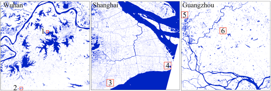
this work we propose a spatial information-integrated small water bodies mapping (SWM) method to achieve a complete and accurate extraction and temporal change monitoring of small water bodies in complex urban environments. Our strategy is to make use of the spatial contextual information to account for the indistinguishability of small water bodies in spectral information. The roughness of the water index is calculated to enhance the contrast between water bodies and other thematic classes eventually present in the imagery. The proposed SWM was applied to different water indexes with an automatic threshold determination. We tested the effectiveness of the proposed algorithm using Landsat and Sentinel-2 multispectral data from three different urban environments (Shanghai, Guangzhou, and Wuhan in China) which include a variety of river courses and lakes. Nantan Lake of China is selected as a representative experimental area to test the SWM method by generating the inter- and intra-year water results. Overall accuracy (OA), F1 score (F1), producer’s accuracy (PA), and user’s accuracy (UA) were used to quantitatively evaluate the accuracy of the algorithm. Compared with the four state-of-the-art water detection methods (supervised random forest classification, hierarchical
clustering, multi-band threshold, and modified normalized difference water index (MNDWI)), the proposed SWM algorithm achieves better water extraction performance. Small water bodies are found to be extracted more completely and incorrect water extractions are alleviated. The overall accuracy of the SWM algorithm achieves an average of approx. 97% (OA) and 0.95 (F1). The long-time sequence (from 2007 to 2021) and the short-time in


