Researchers from the Technical University of Munich (TUM), the Earth Observation Center (EOC) of the German Aerospace Center (DLR) in Oberpfaffenhofen, and our Earth Observation Research Cluster (EORC) of the University of Würzburg teamed up for a study on large-scale urban population estimation using Earth observation data. The paper titled “Interpretable deep learning for consistent large-scale urban population estimation using Earth observation data” was just published in the International Journal of Applied Earth Observation and Geoinformation by Sugandha Doda, Matthias Kahl, Kim Ouan, Ivica Obadic, Yuanyuan Wang, Hannes Taubenböck and Xiao Xiang Zhu.
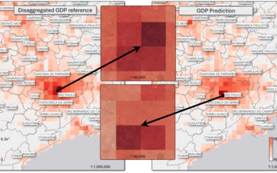
Here is the abstract of the paper: Accurate and up-to-date mapping of the human population is fundamental for a wide range of disciplines, from effective governance and establishing policies to disaster management and crisis dilution. The traditional method of gathering population data through census is costly and time-consuming. Recently, with the availability of large amounts of Earth observation data sets, deep learning methods have been explored for population estimation; however, they are either limited by census data availability, inter-regional evaluations, or transparency. In this paper, we present an end-to-end interpretable deep learning framework for large-scale population estimation at a resolution of 1 km that uses only the publicly available data sets and does not rely on census data for inference. The architecture is based on a modification of the common ResNet-50 architecture tailored to analyze both image-like and vector-like data. Our best model outperforms the baseline random forest model by improving the RMSE by around 9% and also surpasses the community standard product, GHSPOP, thus yielding promising results. Furthermore, we improve the transparency of the proposed model by employing an explainable AI technique that identified land use information to be the most relevant feature for population estimation. We expect the improved interpretation of the model outcome will inspire both academic and non-academic end users, particularly those investigating urbanization or sub-urbanization trends, to have confidence in the deep learning methods for population estimation.
Here is the link to the full paper: https://www.sciencedirect.com/science/article/pii/S1569843224000852
This work is also related to earlier works on this domain:
https://journals.plos.org/plosone/article?id=10.1371/journal.pone.0274504
https://www.nature.com/articles/s41597-022-01780-x