New publication on mapping flood susceptibility
Researchers from the Earth Observation Center (EOC) of the German Aerospace Center (DLR) in Oberpfaffenhofen, the Image Processing Laboratory of the University of València, the Department of Geography of the University of Bonn and our Earth Observation Research Cluster (EORC) of the University of Würzburg teamed up for a study on mapping flood susceptibility. The paper titled “A comparative assessment of data-driven flood susceptibility mapping in Nigeria” was just published in the journal Natural Hazards by Wilmer Fabian Montien Tique, Marta Sapena, Matthias Weigand, Sandro Groth, Christian Geiß and Hannes Taubenböck.
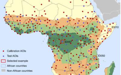
Here is the abstract of the paper: Flood risk in West Africa, particularly Nigeria, has significantly increased over the past 5 decades due to changing hydrological conditions, insufficient mitigation measures, and limited adaptation efforts. This study responds to the need for accurate and high-resolution data to support effective disaster risk management by developing a nationwide, 30 m flood susceptibility map using only open-access data and scalable methods. Leveraging open-access and multi-source remote sensing and geospatial datasets, we systematically compared four digital elevation models (DEMs) and four hydrological methods (D8, D-inf, FD8, and Rho8). Additional flood-influencing factors, including land cover, soil characteristics, and proximity to water bodies, were also incorporated to capture the complex drivers of flood susceptibility. Three machine learning models were developed and evaluated: random forest, binary logistic regression, and linear discriminant analysis. Across all models, the highest accuracy was achieved using the Copernicus DEM in combination with the D8 and FD8 methods. Model performance was validated against the September–October 2022 floods, one of the most catastrophic and well-documented events in Nigeria, demonstrating a strong predictive capability. To reconcile differences among model outputs, we generated an ensemble map that consolidates their strengths while accounting for uncertainty. Compared with previous studies our approach demonstrates how open and reproducible methods can be scaled to the national level and to other African countries. We estimated that approximately 11 million people in Nigeria live in flood-prone areas, underscoring the urgency of integrating susceptibility information into disaster risk management and spatial planning. Our results provide actionable insights for policymakers and practitioners: delineating high-risk zones for land-use regulation, avoiding urban expansion in
floodplains, and prioritizing mitigation and adaptation measures. To promote transparency and reproducibility, we release both the scripts and the final flood susceptibility maps for Nigeria (https://figshare.com/s/dc2318c9884f57b22c0d).
Here is the link to the full paper: https://link.springer.com/article/10.1007/s11069-025-07868-y
This research contributes to our works on natural hazards, exposure, vulnerability, susceptibility and risks – for some further reading on recent papers, please see here:
- Bottom-up building exposure modeling with multimodal earth vision https://www.sciencedirect.com/science/article/pii/S0924271625004241
- Rapid domain adaptation for disaster impact assessment: remote sensing of building damage after the 2021 Germany floods https://www.sciencedirect.com/science/article/pii/S2666017225000938
- BayeSiamMTL: uncertainty-aware multitask learning for post-disaster building damage assessment https://www.sciencedirect.com/science/article/pii/S1569843225004066
- Multi-sensor Near-Realtime Burnt Area Monitoring using a Superpixel-based Graph Convolutional Network approach https://www.tandfonline.com/doi/full/10.1080/15481603.2025.2498188
- Erosion controls vent migration – Home Reef (Tonga) 2022-2024 evolution process analyzed from space https://www.nature.com/articles/s41598-025-95197-2.pdf
- From global risk reduction goals to local impacts through a new approach for multi-risk assessment https://nhess.copernicus.org/articles/24/4631/2024/
- Insights into the Development of a Landslide Early Warning System Prototype in an Informal Settlement: the Case of Bello Oriente in Medellín, Colombia https://nhess.copernicus.org/articles/24/1843/2024/
- Cost estimation for the monitoring instrumentalization of Landslide Early Warning Systems https://nhess.copernicus.org/articles/23/3913/2023/
- Benefits of Global Earth Observation Missions for Exposure Estimation and Earthquake Loss Modelling – Evidence from Santiago de Chile, Chile https://link.springer.com/article/10.1007/s11069-022-05672-6
- Multitemporal Landslide Exposure and Vulnerability Assessment in Medellín, Colombia https://link.springer.com/article/10.1007/s11069-022-05679-z