New publication on the quantitative assessment and comparison of urban patterns in Germany and the USA
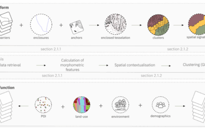
Researchers from the Munich University of Applied Sciences (MUAS) in Munich, the Research Institute for Regional and Urban Development (ILS) in Dortmund, the Earth Observation Center (EOC) of the German Aerospace Center (DLR) in Oberpfaffenhofen and the University of Würzburg in Würzburg teamed up for a comparison of settlement patterns between Germany and the USA. The paper titled “Quantitative assessment and comparison of urban patterns in Germany and the United States” was just published in the Journal Computers, Environment & Urban Systems by Andreas Schmitt, Philipp Uth, Ines Standfuß, Bastian Heider, Stefan Siedentop & Hannes Taubenböck. They developed methods to assess the homogeneity of the settlement landscape and to identify settlement clusters in terms of location and size.
From the Abstract: In this paper, we present methods to assess the homogeneity of the settlement landscape and to identify settlement clusters in terms of location and size. Due to various input data, methodologies, and spatial concepts, there are only a few international comparative research studies with quantitative, spatial approaches to date. Existing studies are mostly qualitative and empirically hardly replicable. Here, we introduce two novel methodological approaches to describe urban land patterns in a numerically stable, consistent and globally comparable manner. The first method evaluates the multi-scale homogeneity of the settlements and the respective density distributions in a purely non-parametric approach. The second method transfers the settlement patterns into a Gaussian Mixture Model via hierarchical multi-scale clustering in order to describe each cluster by the parameters of a 2D Gaussian distribution. In order to proof the robustness of both approaches, two different
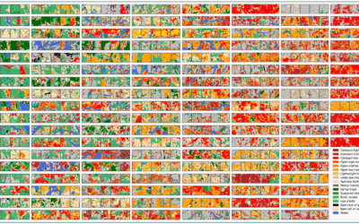
reference units are considered for the interpretation of the results: OECD functional urban areas and standardized subsets of 200 km × 200 km around the same central cities. We show that German urban areas are characterized by a higher heterogeneity within a smaller neighbourhood with an almost symmetric density distribution in comparison to urban areas in the U.S. Furthermore, German urban areas possess an increasing homogeneity with increasing size, i.e., the larger the urban agglomeration, the more uniform it appears. It is the contrary in the U.S. These findings are substantiated by the analysis of individual city centres. In Germany, many clusters of similar size define the urban region, whereas in the U.S. one large dominating cluster exceeds most neighbouring settlements significantly. The study is performed on the Global Urban Footprint Density, which assigns a density value to each urban pixel of about 30 m by 30 m. In this way, the approach is a blueprint to be extended to urban patterns of any spatial unit worldwide.
Read the full article here: https://www.sciencedirect.com/science/article/pii/S0198971522001648?dgcid=author