New publication on the underestimation of slum dwellers in cities of the Global South
Researchers from the Technical University of Darmstadt, the Earth Observation Center (EOC) of the German Aerospace Center (DLR) in Oberpfaffenhofen and our Earth Observation Research Cluster of the University of Würzburg teamed up for a study on the underestimation of slum dwellers in cities of the Global South. The paper titled “The unseen population: Do we underestimate slum dwellers in cities of the Global South?” was just published in the journal Habitat International by Julius H.P. Breuer, John Friesen, Hannes Taubenböck, Michael Wurm and Peter F. Pelz. This study has been conducted as part of the research project “Uniform detection and modelling of slums to determine infrastructure needs” (Grant ID: LOEWE/5/A002/519/06/00.003(0003)/E15) funded by the LOEWE Program of Hesse State Ministry for Higher Education, Research and the Arts.
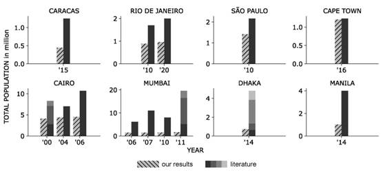
Here is the abstract of the paper: The Sustainable development goals (SDG) aim for reducing poverty (SDG 1) and to upgrade all slums (SDG 11). The first indicator in SDG 11 describes the proportion of the urban population residing in slums. However, the currently available data is based on national estimates that follow globally varying methodologies and concepts. In this paper, a uniform approach is implemented to obtain slum population estimates in eight different cities from three continents. The approach relies on earth observation datasets on the spatial extent of the slums and one of the most accepted gridded population dataset: WorldPop. The results shed light on the distribution of population in slums around the world. Nevertheless, the question of the accuracy of these population numbers arises. Therefore, a broad range of literature data containing population counts is gathered for the cities investigated, for varying years and for different spatial scales. The literature data is compared to results obtained by the presented approach. The comparison yields a plausibility assessment for different cities, indicating varying levels of deviation. We find in all cities a clear bias in estimating the slum population – mostly underestimations -, even though some cities reveal a significantly better fit to the data. In conclusion, this study provides a methodology to systematically assess the accuracy of globally available datasets in the context of slums and thereby to highlight the large uncertainties which can empirically be observed.
Please find the full paper here: https://www.sciencedirect.com/science/article/pii/S0197397524000560

