New Publication: Review on remotely sensed tree species mapping

New Publication: Review on remotely sensed tree species mapping

September 8, 2016

A new review paper featuring Dr. Hooman Latifi as the second author has been recently published by Remote Sensing of Environment. The paper is a product of more than 1 year intensive teamwork of a group of well-known international scholars, and focuses on a meta analysis of reviewed studies on tree species classification by means of remotely sensed data. The authors finally recommend that future research should focus rather on the causal understanding of why tree species classification approaches work under certain conditions or – maybe even more important -why they do not work in other cases. This might require more complex field acquisitions than those typically used in the reviewed studies.

The paper also recommends reducing the number of purely data-driven studies and algorithm benchmarking studies as these studies are of limited value, especially if the experimental design is limited, e.g. the tree population is not representative and only a few sensors or acquisition settings are simultaneously investigated.

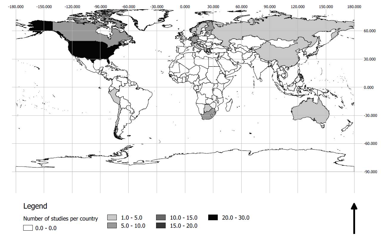
World map displaying where the 116 selected studies have been conducted

Further information on this review paper can be found here.

Source:

Fassnacht, F.E., Latifi, H., Ghosh, A., Stereńczak, K., Modzelewska, A., Lefsky, M., Waser, L., Straub, C. 2016. Review of studies on tree species classification from remotely sensed data. Remote Sensing of Environment 186: 64-87.


you may also like:

our research covered by television

our research covered by television

At the opening of the CAIDAS we also had the opportunity to present our research and development work to various media representatives. For example, we reported on our remote sensing work to ARD and Bayerischer Rundfunk as well as for Mainfranken TV - see e.g. here...

Our research introduced to the JMU president Pauli

Our research introduced to the JMU president Pauli

At the Center for Artificial Intelligence and Data Science (CAIDAS) opening last Friday on 18th of April 2024, we had the opportunity to present the research of our Earth Observation Research Cluster (EORC) and of the Earth Observation Center (EOC) of the German...

UAS mission of monastery Bronnbach

UAS mission of monastery Bronnbach

The potential of UAS data for mapping cultural heritage sites was discussed in the past months with colleagues associated with the UNESCO world heritage activities by our postdocs Dr. Mirjana Bevanda and Dr. Sarah Schönbrodt-Stitt. Based on these discussions further...

Internship Report on Tuesday, April 30 at 14:00

Internship Report on Tuesday, April 30 at 14:00

On Tuesday, April 30 Konstantin Müller will present his internship " GDELT News Analysis of the Noto Earthquake via ERNIE" at 14:00 in 01.B.03, John-Skilton-Str. 4a. : From the abstract: The analysis of socioeconomic data has gained increasing importance. The exchange...

Internship Report on Tuesday, April 23 at 12:00

Internship Report on Tuesday, April 23 at 12:00

On Tuesday, April 23rd Elly Schmid will present her internship at 12:00 in seminar room 3, John-Skilton-Str. 4a. : From the abstract: The internship was carried out as part of the HEATS-(Urban heat) Project of the Georisks team at the Earth Observation Center, which...

New building for the CAIDAS AI center opened

New building for the CAIDAS AI center opened

CAIDAS, the Center for Artificial Intelligence and Data Science ( https://www.caidas.uni-wuerzburg.de/ ), was officially opened on April 19, 2024 with prominent guests from politics and science.  Bavaria's Minister of Science Markus Blume cut the ribbon for the new...