New publication: Three-dimensional subsurface architecture and its influence on the spatiotemporal development of a retrogressive thaw slump in the Richardson Mountains, Northwest Territories, Canada

New publication: Three-dimensional subsurface architecture and its influence on the spatiotemporal development of a retrogressive thaw slump in the Richardson Mountains, Northwest Territories, Canada

March 6, 2023

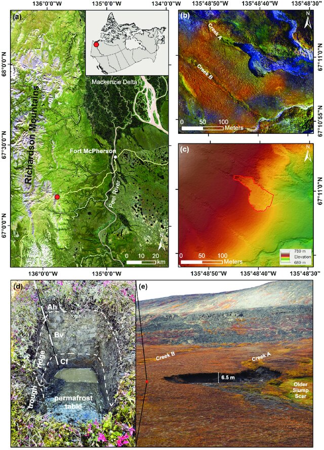
Lead by our colleagues Julius Kunz, Christof Kneisel and Roland Baumhauer from the Department of Physical Geography (University of Würzburg), we just published a new paper titled “Three-dimensional subsurface architecture and its influence on the spatiotemporal development of a retrogressive thaw slump in the Richardson Mountains, Northwest Territories, Canada”

From the abstract: The development of retrogressive thaw slumps (RTS) is known to be strongly influenced by relief-related parameters, permafrost characteristics, and climatic triggers. To deepen the understanding of RTS, this study examines the subsurface characteristics in the vicinity of an active thaw slump, located in the Richardson Mountains (Western Canadian Arctic). The investigations aim to identify relationships between the spatiotemporal slump development and the influence of subsurface structures. Information on these were gained by means of electrical resistivity tomography (ERT) and ground-penetrating radar (GPR). The spatiotemporal development of the slump was revealed by high-resolution satellite imagery and unmanned aerial vehicle–based digital elevation models (DEMs).
Read the full article (open access) here: https://go.uniwue.de/mm47c

you may also like:

Bridging Scales: How Radar Satellites supports Crop Monitoring

Bridging Scales: How Radar Satellites supports Crop Monitoring

In an era of climate uncertainty and increasing pressure on agricultural systems, understanding how crops grow and respond to environmental stress is more important than ever. A new study led by researchers from Martin-Luther-University Halle-Wittenberg, in close...

New paper on automated pollinator monitoring using time-lapse images

New paper on automated pollinator monitoring using time-lapse images

Researchers from Helmholtz Centre for Environmental Research (UFZ) in Leipzig, the German Centre for Integrative Biodiversity Research (iDiv) in Leipzig, the Martin Luther University Halle-Wittenberg, the German Remote Sensing Data Center (DFD) of the German Aerospace...

Media reporting on “understanding urban heat in Germany”

Media reporting on “understanding urban heat in Germany”

We recently reported on the urban heat island effect in Germany and the work of DLR and EORC on the topic – please see here: https://remote-sensing.org/understanding-urban-heat-in-germany-insights-from-prof-hannes-taubenbocks-research/   Here is a link to...

Proceedings of JURSE published

Proceedings of JURSE published

Our EORC and our colleagues from DLR have contributed with various research works to the Joint Urban Remote Sensing Event (JURSE) 2025. This bi-annual conference took place in Tunis, Tunisia, in early May 2025. JURSE is committed to introduce innovative methodologies...

DLR supports Zeit Magazine with Land Surface Temperature data

DLR supports Zeit Magazine with Land Surface Temperature data

Our colleagues from DLR provided long-term Land Surface Temperature (LST) data for an interactive tool in the Zeit Magazine which was recently published online https://www.zeit.de/zeit-magazin/2025-06/stadtteile-grossstaedte-wohnen-deutschland-lebensqualitaet The tool...