New publication: Unveiling urban ecological integrity: spatially explicit assessment in contrasting environments

New publication: Unveiling urban ecological integrity: spatially explicit assessment in contrasting environments

February 14, 2024

The new paper titled “Unveiling urban ecological integrity: spatially explicit assessment in contrasting environments” has been published in the journal “Urban Ecosystems” by a member of the Earth Observation Research Cluster (EORC) in cooperation with colleagues from the University of Helsinki.


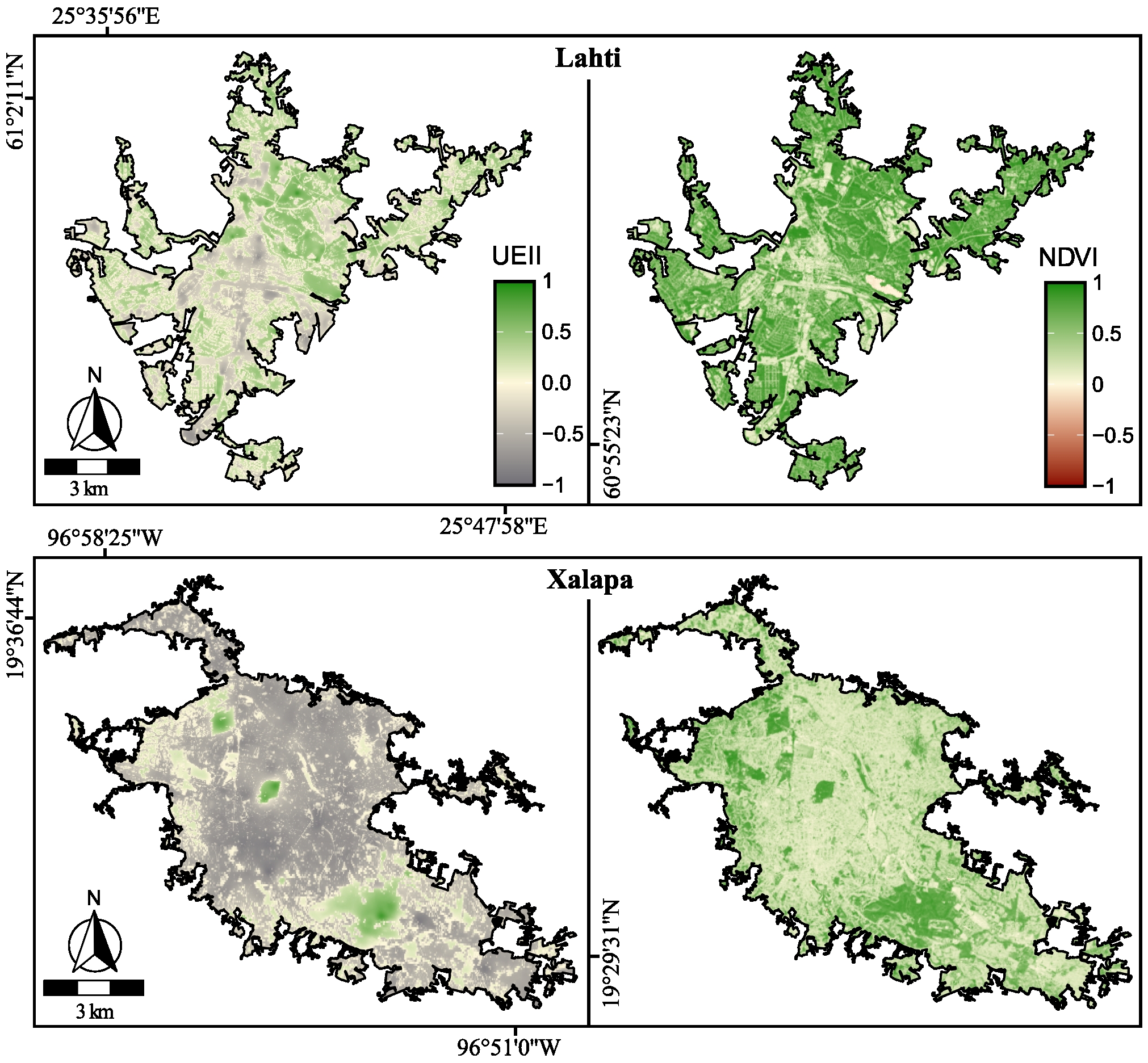
In this research, the authors tested their previously proposed Urban Ecosystem Integrity Index (UEII) in the contrasting environments of Lahti, Finland (a boreal city) and Xalapa, Mexico (neotropical) and compared it to the widely used NDVI. The UEII spatially explicitly represents the urbanization intensity (built-up, surface temperature) and the biological (plants and birds richness) components of cities based on remote sensing and field survey data. The UEII showed to be robust, comparable, and effective in capturing the intra and inter-urban spatial heterogeneity of both cities. Unlike the NDVI –often suggested as a proxy of ecological quality– the UEII provides a more comprehensive understanding of the ecological value of both built-up and greenspaces, making it a promising tool for identifying priority areas for habitat preservation within urban settings, as well as those in need of further improvements. The UEII aims to help shaping environmental initiatives and budget allocations aimed at establishing more ecologically friendly, biodiverse, and livable urban environments.


The open access paper can be found here: https://link.springer.com/article/10.1007/s11252-024-01517-1

you may also like:

Our research site and project covered by BR

Our research site and project covered by BR

The University forest at Sailershausen is a unique forest owned by the University of Wuerzburg. It comes with a high diversity of trees and most important is part of various research projects. We conducted various UAS/UAV/drone flights with Lidar, multispectral and...

Meeting of the FluBig Project Team

Meeting of the FluBig Project Team

During the last two days, the team of the FluBig project (remote-sensing.org/new-dfg-project-on-fluvial-research/) met at the EORC for discussing the ongoing work on fluvial biogeomorphology. After returning from a successful field expedition to Kyrgyzstan a couple of...

‘Super Test Site Würzburg’ project meeting

‘Super Test Site Würzburg’ project meeting

After the successful "Super Test Site Würzburg" measurement campaign in June (please see here: https://remote-sensing.org/super-test-site-wurzburg-from-the-idea-to-realization/ ), the core team from the University of Würzburg, the Karlsruhe Institute of Technology,...

EORC Talk: Geolingual Studies: A New Research Direction

EORC Talk: Geolingual Studies: A New Research Direction

On July 19th, Lisa Lehnen and Richard Lemoine Rodríguez, two postdoctoral researchers of the Geolingual Studies project, gave an inspiring presentation at the EORC talk series.   In the talk titled "Geolingual Studies – a new research direction", they...

EO support for UrbanPArt field work

EO support for UrbanPArt field work

From May to September, Karla Wenner, a PhD student at the Juniorprofessorship for Applied Biodiversity Science, will be sampling urban green spaces and semi-natural grasslands in Würzburg as part of the UrbanPArt project. Our cargo bikes support the research project...

Cinematic drone shots

Cinematic drone shots

We spend quite some time in the field conducting field work, from lidar measurements to vegetation samples in order to correlate it with remote sensing data to answer various research questions concerning global change. Field work is always a 24/7 work load and...