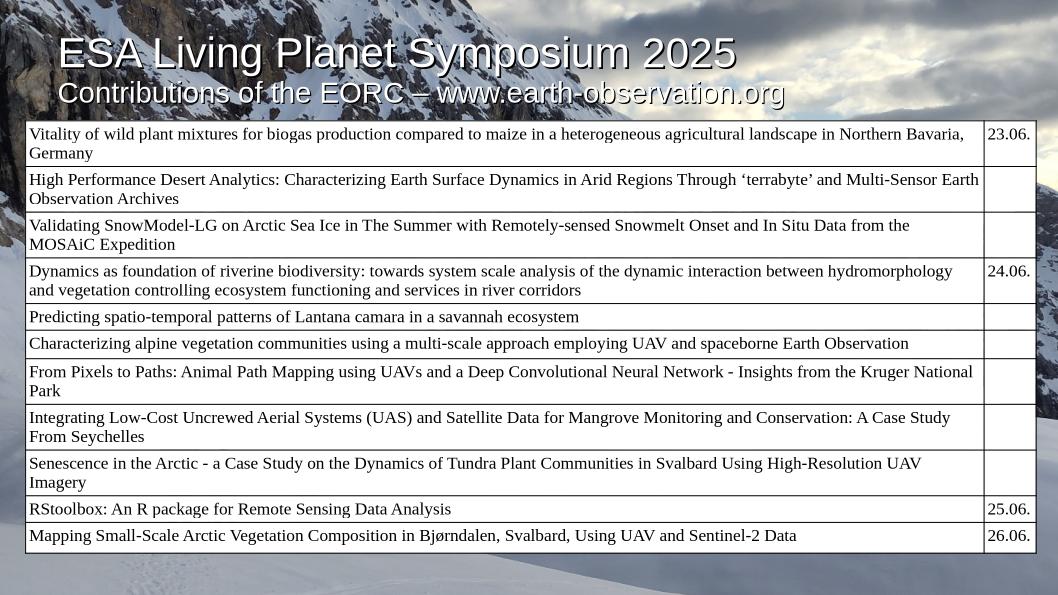
This week, the global Earth observation community gathered in Vienna for the ESA Living Planet Symposium 2025 — one of the most anticipated events for anyone passionate about understanding our planet through remote sensing. Our team was proud to contribute with an exciting range of research projects, covering topics from Arctic snow to African savannahs, from desert analytics to digital urban studies.
Here’s a glimpse into the Earth system research presented by our staff and EAGLE students:
🌾 Rethinking Agriculture: From Biogas to Food Security
Vitality of wild plant mixtures for biogas production compared to maize in Northern Bavaria
In an era of energy transition, we explored how diverse wild plant mixtures can outperform conventional maize in promoting biodiversity, soil health, and landscape resilience, offering a more sustainable future for bioenergy production in Germany’s agricultural heartland.
Winter Wheat and Oilseed Rape Yields: Remote Sensing Fusion and Machine Learning in Bavaria
We combined two decades of Landsat and MODIS satellite data with machine learning to predict yields of key crops, revealing new insights for precision agriculture and food security.
🏜️ High Performance Analytics for Extreme Environments
Desert Dynamics: ‘terrabyte’ Platform and Multi-Sensor EO for Arid Regions
Our High Performance Desert Analytics framework leverages massive EO archives and AI-driven tools to decode the shifting landscapes of deserts — critical for climate change adaptation and water management.
Senescence in the Arctic: Tundra Plant Dynamics in Svalbard
High-resolution UAV imagery captured the subtle signs of plant senescence in the Arctic, helping us understand vegetation shifts under rapid polar warming.
❄️ Snow, Ice, and Permafrost in a Changing Climate
Validating SnowModel-LG on Arctic Sea Ice with MOSAiC Data
Using remotely sensed snowmelt onset and unique in situ data from the MOSAiC expedition, we tested snow models crucial for understanding sea ice decline in the Arctic summer.
Rock Glacier Velocity Monitoring with InSAR
Our work advances standardized methods to track rock glacier movement — a key Essential Climate Variable for understanding mountain permafrost stability.
🌍 Ecosystem Monitoring from Rivers to Forests
Riverine Biodiversity: System-Scale Hydromorphology-Vegetation Interactions
We aim to bridge the gap between river dynamics and biodiversity patterns, unlocking new approaches to restore and sustain healthy river corridors.
Lantana camara Spread Prediction in Savannah Ecosystems
Invasive species threaten biodiversity — we modeled spatio-temporal patterns of Lantana camara to support targeted management in African savannahs.
Mapping Alpine Vegetation with UAVs and Satellites
Our multi-scale approach reveals how alpine plant communities respond to environmental change, combining spaceborne and drone-based Earth observation.
Forest Health and Climate Envelopes for Germany’s Reforestation Strategy
Leveraging EO and climate data, we provide tools to optimize reforestation efforts, ensuring forests thrive under shifting environmental conditions.
🛰️ Innovations in Remote Sensing Tools and Data Integration
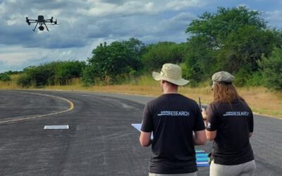
From Pixels to Paths: Mapping Animal Trails in Kruger National Park with UAVs and AI
We used UAVs and deep learning to map wildlife movement paths, offering unprecedented detail to support conservation efforts in South Africa.
Mangrove Monitoring in Seychelles: Integrating Low-Cost UAS and Satellite Data
In this coastal case study, we demonstrated how drones and EO can empower communities to conserve vital mangrove ecosystems.
RStoolbox: Open-Source Remote Sensing Analysis with R
Our R package streamlines satellite data analysis, making advanced EO techniques accessible for researchers worldwide.
Comparing Sentinel-2 and High-Resolution UAS Data for Forestry
We assessed how well satellite and drone data align, unlocking synergies for next-generation forest monitoring.
🏙️ Cities, Climate, and Society
Scalable Climate Monitoring for Urban Adaptation in Bavaria
Urban heat is rising — we integrated diverse temperature datasets to support cities in building climate resilience.
EO4ConStat: Earth Observation and AI for Construction Statistics
Our project explores how satellite data can fill gaps in tracking construction activities, offering real-time insights for urban planning.
Geolingual Studies: Merging Linguistics, Digital Humanities, and EO for Urban Analysis
We introduced a novel approach blending language patterns and EO data to explore the physical and social dimensions of urban spaces.
Social Media Meets Remote Sensing: Migration Insights for Ghana
By fusing EO with social media data, we developed a new lens to explore migration patterns, bridging the gap between environmental and human dynamics.
🌱 Grasslands and Vegetation Insights Across Scales
EU-Wide Grassland Biomass Estimation with Sentinel-2 and LUCAS Data
Our models provide crucial data on grassland productivity, informing sustainable land management across Europe.
TreeCompR: Standardizing Tree Competition Analysis with 3D Data
We unveiled a powerful tool to quantify tree competition from inventory data or 3D point clouds, enhancing forest management precision.
Mapping Arctic Vegetation in Svalbard Using UAV and Sentinel-2
Combining drones and satellites, we achieved fine-scale mapping of fragile Arctic vegetation — a vital step for monitoring climate change impacts.
Drought Monitoring in Orchard Meadows
By integrating geophysics and EO, we developed new methods to track drought stress in biodiversity-rich orchard meadows, supporting their conservation.
Looking Ahead
The ESA Living Planet Symposium 2025 showcase how interdisciplinary research and Earth observation technologies are converging to tackle the planet’s most pressing environmental challenges. We are proud to contribute with research spanning ecology, agriculture, climate monitoring, and AI-driven analysis — all rooted in the belief that better data leads to better decisions for our planet’s future.
Stay tuned for more insights and publications from our ongoing research!