Publication: How Phenology Shapes Crop-Specific Sentinel-1 PolSAR Features and InSAR Coherence across Multiple Years and Orbits

Publication: How Phenology Shapes Crop-Specific Sentinel-1 PolSAR Features and InSAR Coherence across Multiple Years and Orbits

July 31, 2024

New Publication by University of Halle and EORC on crop-specific signatures in Sentinel-1 time series. From the abstract:

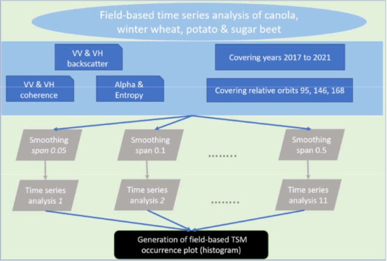
Spatial information about plant health and productivity are essential when assessing the progress towards Sustainable Development Goals such as life on land and zero hunger. Plant health and productivity are strongly linked to a plant’s phenological progress. Remote sensing, and since the launch of Sentinel-1 (S1), specifically, radar-based frameworks have been studied for the purpose of monitoring phenological development. This study produces insights into how crop phenology shapes S1 signatures of PolSAR features and InSAR coherence of wheat, canola, sugar beet. and potato across multiple years and orbits. Hereby, differently smoothed time series and a base line of growing degree days are stacked to estimate the patterns of occurrence of extreme values and break points. These patterns are then linked to in situ observations of phenological developments. The comparison of patterns across multiple orbits and years reveals that a single optimized fit hampers the tracking capacities of an entire season monitoring framework, as does the sole reliance on extreme values. VV and VH backscatter intensities outperform all other features, but certain combinations of phenological stage and crop type are better covered by a complementary set of PolSAR features and coherence. With regard to PolSAR features, alpha and entropy can be replaced by the cross-polarization ratio for tracking certain stages. Moreover, a range of moderate incidence angles is better suited for monitoring crop phenology. Also, wheat and canola are favored by a late afternoon overpass. In sum, this study provides insights into phenological developments at the landscape level that can be of further use when investigating spatial and temporal variations within the landscape.

you may also like:

Blender GIS introduction

Blender GIS introduction

Within out EAGLE Earth Observation M.Sc. we also cover software applications which might not be used on a regular basis within our field of research but are sometimes highly useful to display our spatial data in a visually appealing way - and also potentially provides...

EAGLE presentation by Gökçe Yağmur Budak

EAGLE presentation by Gökçe Yağmur Budak

On November 26, 2024, Gökçe Yağmur Budak will present her internship results on " Leveraging Data-Driven Approaches for Seismic Risk Assessment in Istanbul " at 12:30 in seminar room 3, John-Skilton-Str. 4a. From the abstract: This internship aims to create time...

JURSE – deadline for paper submission extended

JURSE – deadline for paper submission extended

JURSE - Joint Urban Remote Sensing Event   The 17th International Conference on Joint Urban Remote Sensing (JURSE), organized by Higher School of Communication of Tunis (SUP'COM) will take place in Tunisia from 4 to 7 May 2025. https://2025.ieee-jurse.org/ ;...

Professor Appolonia A. Okhimamhe visits DLR

Professor Appolonia A. Okhimamhe visits DLR

This week, we were delighted to welcome Professor Appolonia A. Okhimamhe from the Federal University of Technology (FUT) Minna, Nigeria, to the German Aerospace Center (DLR). She is a Professor of Geography and the Director of the Doctoral Programme on Climate Change...

PHD DEFENSE BY PATRICK ARAVENA PELIZARI ON DECEMBER 12, 2024

PHD DEFENSE BY PATRICK ARAVENA PELIZARI ON DECEMBER 12, 2024

On December 12, 2024, Patrick Aravena Pelizari will defend his doctoral thesis entitled "Multihazard-Expositionsmodellierung mit multimodalen Geobilddaten und Deep Learning" at the University of Würzburg. In his work, Patrick Aravena Pelizari explored the potential of...