
Satellite data for disaster response: Insights from the Valencia floods
Over recent days, we’ve all seen the heartbreaking images and videos from the catastrophic floods that hit L’Horta Sud, Valencia, on the night of October 29, 2024. At times like these, the critical role of satellite data in understanding and responding to disasters becomes clear. Through multispectral imagery and radar data, satellites can map flood extents and depths, penetrating cloud cover to provide detailed insights into the scale of damage. This data is invaluable for quantifying damage and assessing the flood’s impact on affected communities.
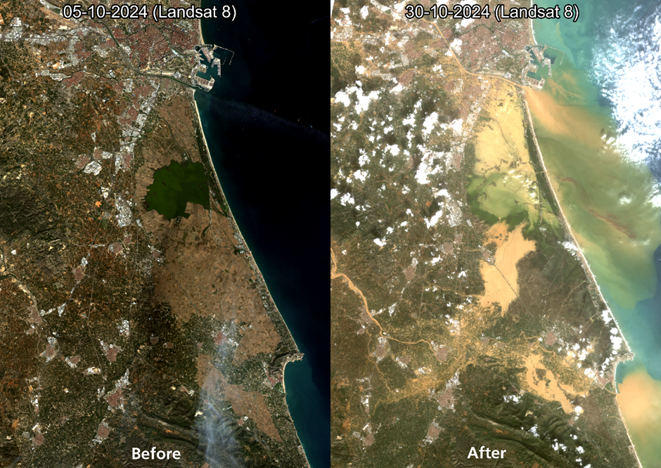
The image above shows two Landsat 8 snapshots—one before the event on October 5, 2024, and another after on October 30, 2024. These images reveal the extent of flooded areas through visible traces of mud and sediment carried by rivers and streams. This post-flood mapping is crucial in showing how floodwaters have reshaped the landscape and identifying high-impact areas in need of immediate aid.
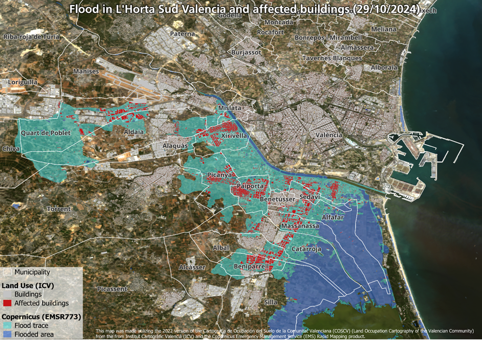
Additionally, the Emergency Monitoring Service (EMS) from Copernicus has mapped flooded zones in detail. We overlaid this map with a land-use map from the Institut Cartogràfic Valencià (ICV) to map affected buildings in red. According to EMS estimates, more than 200,000 people have been impacted by the flood, with damage spanning a significant portion of local infrastructure.
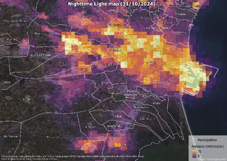
Beyond daytime imaging, nighttime satellite data from the Visible Infrared Imaging Radiometer Suite Day/Night Band (VIIRS/DNB) captures the intensity of lights emitted from Earth at night. This “Nighttime Light” (NTL) data is a powerful tool for monitoring urbanization, estimating economic impacts, and assessing disaster effects.
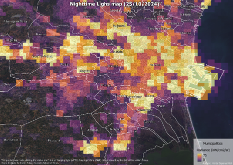
The images below shows changes in nighttime light emissions around Valencia before and after the flood. These shifts underscore the hardship many towns and cities face after a disaster, with several southern Valencia towns cut off from essentials such as water, food, and electricity. Thankfully, electricity has been restored to many areas, and volunteers and institutions are working tirelessly to distribute food, water, and other essentials.
The economic repercussions are also profound. The Valencia’s Commercial Chamber reports that the disaster has impacted nearly every economic sector, from agriculture and industry to services. The affected municipalities are home to 54,289 companies—one out of every three in the province—as well as 123 business parks and industrial estates. In many of these areas, the severity of damage is high, affecting not only housing and infrastructure but also local economic activity at a scale that will take significant time to recover.
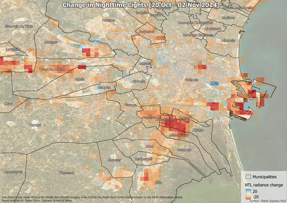
A Nighttime Light change map (below) reveals the widespread halt in activity across key industrial zones around Valencia, including the “Pista de Silla” (covering Sedaví, Alfafar, Massanassa, Catarroja, Albal, Beniparrell, and Silla), “El Oliveral” in Riba-roja del Túria, Aldaia, and Quart de Poblet industrial zones, and even Manises Airport. The interruption in power and economic activities in these regions highlights the extensive economic disruption, as businesses and supply chains across the area struggle to resume operations.
In the face of natural disasters, satellite data serves as a vital resource for rapid response and recovery, enabling precise damage assessment, resource allocation, and strategic planning to aid communities on the road to recovery.
Sending all our support to the people affected ❤️.
This article and the accompanying analysis were prepared by Dr. Marta Sapena-Moll, a German Aerospace Center (DLR) employee and Valencia native who witnessed the unfolding of this disaster in her hometown. Although the effects of the DANA (a Spanish acronym for Isolated Depression at High Levels, i.e. a weather phenomenon in which cold and warm air meet and produce powerful rain clouds) in the immediate area where she was staying were moderate, it quickly became clear through images shared by friends that this was a catastrophe of historic proportions. Dr. Sapena-Moll works within the Georisk and Civil Security Department (GZS) at the Earth Observation Center (EOC) of the DLR, where she specializes in assessing exposure and vulnerability to natural hazards. Her expertise in disaster risk analysis brings essential insight to understanding the impacts of events like this and underscores the importance of satellite data in supporting communities facing such unprecedented challenges.