
Thermal cameras on drones look very good – visually. They show us temperature of our study objects be it stressed trees, warm patches in a city or active fires. But we do not yet know for sure how far we can trust the temperature values they deliver especially when conditions change fast.
That’s the problem a small cooperative project at the Earth Observation Research Cluster (EORC) is looking at. It’s run by the UAS Research Team, and Antonio José Castañeda-Gómez leads this specific project together with the students Benjamin Guth and Joel Santos Valle. The idea came from previous work (or rather questions concerning the thermal data) and therefore Mirjana Bevanda partnered up with Prof. Marco Schmidt and Moritz Heimbach in order to build an active thermal calibration panel, built to deliver calibrated thermal information.
The core challenge is sensitivity and accuracy. The team needs a controlled thermal environment where they decide what the temperature does. They mimic a typical UAS thermal image acquisition and changes in temperature pattern, then analyze the spatio-temporal accuracy and the time lag between temperature changes and what the camera aquires.
The informatics department build a copper plate panel, cooled actively by four Peltier elements and fitted with thermocouples. Above it hovers our DJI Zenmuse H20T. The plate plays the role of a surface with sudden temperature swings, and the camera shows how well it keeps up.
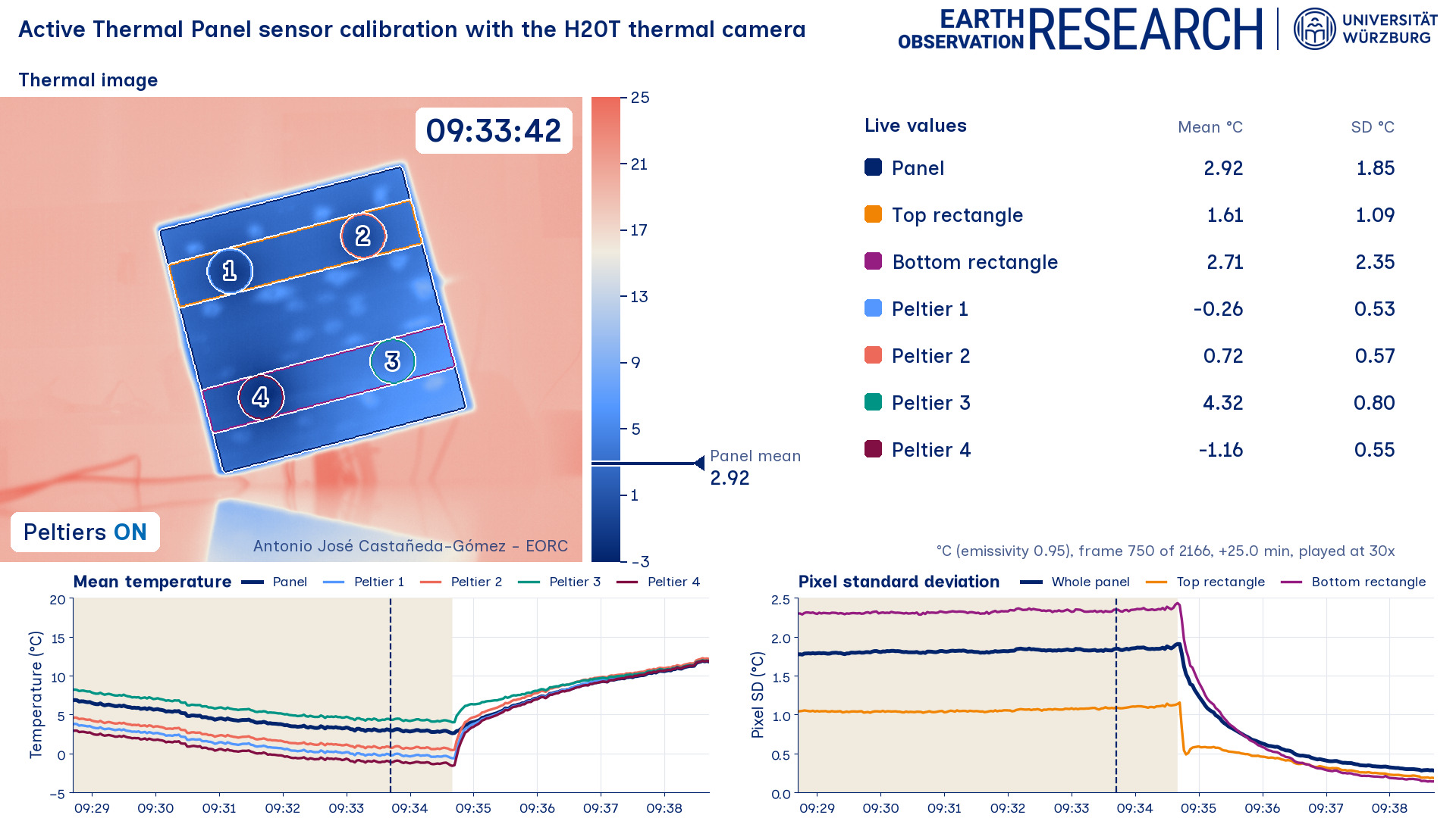
The first test ran by Antonio and the students on November 5, 2026. Four cooling cycles, each pushed until condensation formed, with one thermal image every two seconds over 72 minutes. Preliminary numbers show the panel mean dropping from about 15 to 17 °C down to roughly 3 °C within 8 to 10 minutes. But the cooling wasn’t even, the Peltier elements didn’t all pull their weight equally, so the team uses the pixel standard deviation across the panel as a measure of how homogeneous the cooling really is. In order to check the spatio-temporal results Antonio build a dynamic dashboard for data analysis (seen in the picture) which shows the panel values changing and the corresponding UAS thermal data acquisition responding to it. Quite a nice interface to analyse such data!
Of course the lab controlled environment and testing has an applied reason. A calibrated thermal signal matters for finding dead wood in forests, for understanding fire dynamics in African savannas, and for reading heat patterns in a city context. Stay tuned for an upcoming city thermal CalVal mission in the next weeks – we will report about it once we pulled it off.
It is an important approach by our UAS research team, before they really trust the temperature from the sky, they make sure it can be trusted using a ground CalVal approach.
That’s the problem a small cooperative project at the Earth Observation Research Cluster (EORC) is looking at. It’s run by the UAS Research Team, and Antonio José Castañeda-Gómez leads this specific project together with the students Benjamin Guth and Joel Santos Valle. The idea came from previous work (or rather questions concerning the thermal data) and therefore Mirjana Bevanda partnered up with Prof. Marco Schmidt and Moritz Heimbach in order to build an active thermal calibration panel, built to deliver calibrated thermal information.
The core challenge is sensitivity and accuracy. The team needs a controlled thermal environment where they decide what the temperature does. They mimic a typical UAS thermal image acquisition and changes in temperature pattern, then analyze the spatio-temporal accuracy and the time lag between temperature changes and what the camera aquires.
The informatics department build a copper plate panel, cooled actively by four Peltier elements and fitted with thermocouples. Above it hovers our DJI Zenmuse H20T. The plate plays the role of a surface with sudden temperature swings, and the camera shows how well it keeps up.
The first test ran by Antonio and the students on November 5, 2026. Four cooling cycles, each pushed until condensation formed, with one thermal image every two seconds over 72 minutes. Preliminary numbers show the panel mean dropping from about 15 to 17 °C down to roughly 3 °C within 8 to 10 minutes. But the cooling wasn’t even, the Peltier elements didn’t all pull their weight equally, so the team uses the pixel standard deviation across the panel as a measure of how homogeneous the cooling really is. In order to check the spatio-temporal results Antonio build a dynamic dashboard for data analysis (seen in the picture) which shows the panel values changing and the corresponding UAS thermal data acquisition responding to it. Quite a nice interface to analyse such data!
Of course the lab controlled environment and testing has an applied reason. A calibrated thermal signal matters for finding dead wood in forests, for understanding fire dynamics in African savannas, and for reading heat patterns in a city context. Stay tuned for an upcoming city thermal CalVal mission in the next weeks – we will report about it once we pulled it off.
It is an important approach by our UAS research team, before they really trust the temperature from the sky, they make sure it can be trusted using a ground CalVal approach.