
Here at the Earth Observation Research Cluster, we not only work with satellite or drone data, but also incorporate datasets like weather measurements. For example, one of our partners in the AgriSens DEMMIN 4.0 project is the German Weather Service (DWD), who operate a dedicated agricultural observation infrastructure in our study region around Demmin in the German state of Mecklenburg-Vorpommern. Yesterday they released to us their data for September, which is automatically downloaded from their servers into our infrastructure, where it is converted from the typical meteorological netCDF format into the more cloud-friendly GeoTIFF format and then ingested into our datacube.
As you have probably noticed if you live in Germany, that past September has been unusually warm, so out of curiosity our datacube man Christoph Friedrich started a quick Jupyter Notebook and ran a little analysis on this fresh data, which produced the three graphics below:
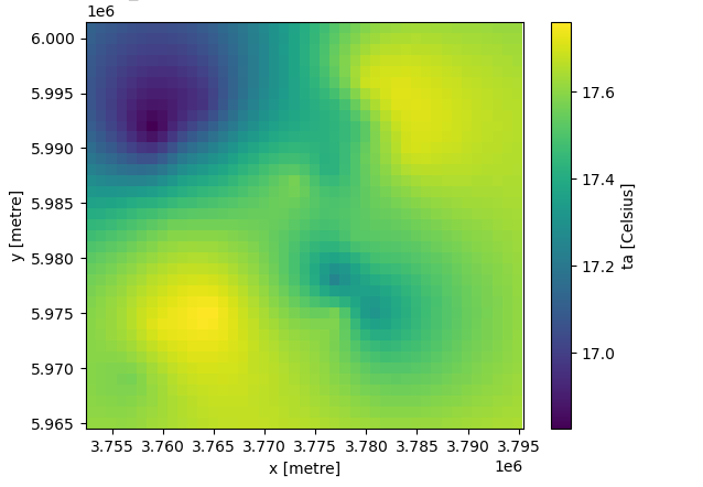
The following map shows the mean air temperature over the entire month. The differences throughout the area may look more extreme than they really are, as a closer look on the legend reveals that the spread between minimum and maximum is less than one degree. This is as expected since the area covers “only” 37 by 43 kilometers in a terrain that is mostly flat.
However, when put into context with the six previous years, a remarkable difference can be seen: The September of 2023 was several degrees warmer than the last years! This observation has to be taken with a grain of salt, as our timeseries of only seven years is nowhere near representative, but it is a very interesting observation nonetheless, as several degrees are a significant margin. (Note that a different colour map was used than in the previous graphic in order to increase contrast within the years.)

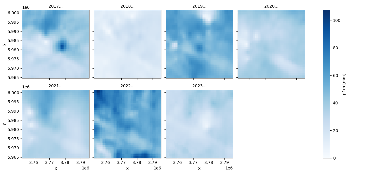
In the next graphic, it is not the mean temperature that is shown, but the sum of rainfall over the whole month. It can be seen that this September was not only warm, but also relatively dry, however this seems to be less uncommon. It also fits into the general fact of Eastern Germany experiencing comparatively low precipitation levels. The combination with warmer temperatures, however, may put additional stress on the agriculture undertaken here.

further reading:
AgriSens project https://www.agrisens-demmin.de/
dedicated agricultural observation infrastructure https://www.dlr.de/eoc/desktopdefault.aspx/tabid-9539/16442_read-40235/
our datacube https://eo2cube.org/