![]() The next AniMove summerschool will be from August 27th to September 9th 2017. This intense 2 weeks course covers how to analyze animal movement data and environmental remote sensing data for ecological applications. We will cover again the remote sensing and spatial data analysis part and how to combine it with movement tracks. Data access and preprocessing will be taught as well as the derivation of ecological relevant remote sensing products. More details can be found on the course page: 2017 AniMove at MPI
The next AniMove summerschool will be from August 27th to September 9th 2017. This intense 2 weeks course covers how to analyze animal movement data and environmental remote sensing data for ecological applications. We will cover again the remote sensing and spatial data analysis part and how to combine it with movement tracks. Data access and preprocessing will be taught as well as the derivation of ecological relevant remote sensing products. More details can be found on the course page: 2017 AniMove at MPI
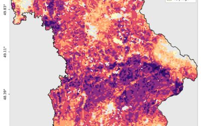
EAGLE MSc Defense: Developing a Farmland Habitat Biodiversity Indicator for Bavaria (in line with OECD Guidelines)
On March 31, 2026, Suriya Elango will present his Master Thesis on " Developing a Farmland Habitat Biodiversity Indicator for Bavaria (in line with OECD Guidelines)" at 12:00 in seminar room 3, John-Skilton-Str. 4a. From the abstract: Farmland Biodiversity is...