fieldRS updated (v0.2.1)

fieldRS updated (v0.2.1)

December 12, 2018

fieldRS 0.2.1 is on CRAN! See the package news for details.


Highlights:

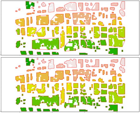
  • extractFields() can draw shapes out of classified images with concave hulls besides the basic convex hulls (see figure)
  • ccLabel() allows change thresholds that are negative (extracts pixels below the threshold) and positive (extracts pixels above the threshold)
  • labelCheck() can automatically correct a character vector without a visual check, provided a set of potential cases
  • rankPlots() includes class diversity/richness as criteria to select sampling sites
Comparison of polygons (in red) drawn with convex hulls (top) and concave hulls (bottom)

you may also like:

Poster Presentation at AK Hydrologie, Bonn

Poster Presentation at AK Hydrologie, Bonn

From November 13 to 15, Sofia Haag and Christian Schäfer attended the AK Hydrologie workshop in Bonn, where they presented their work from the EO4CAM project. The first day featured an insightful field excursion to the Ahrtal region, led by Prof. Dr. Jürgen Herget,...

A Glimpse into Our Research: Data on Display in the Foyer

A Glimpse into Our Research: Data on Display in the Foyer

Stepping into the foyer, visitors are now greeted by large, striking images that tell the story of our research through data. Each visual represents a unique scientific perspective – from the Arctic to the cultivated landscapes of Bavaria, and from forest canopies to...

Successful MSc defense by Sonja Maas

Successful MSc defense by Sonja Maas

Big congratulations to Sonja Maas, who successfully defended her Master thesis today on the highly relevant and increasingly pressing topic: LiDAR-Based Acquisition Strategies for Forest Management Planning in a Mature Beech Stand Supervised by Dr. Julian Fäth and...

Visit at the Institute for Geoinformatics (IFGI) at University of Münster

Visit at the Institute for Geoinformatics (IFGI) at University of Münster

Two days ago, our PostDoc Dr. Jakob Schwalb-Willmann visited the Institute for Geoinformatics at University of Münster to give a talk at IFGI’s GI Forum titled “Can animals be used to classify land use? Employing movement-tracked animals as environmental informants using deep learning”.