 Anna Stephanie handed in her MSc thesis on “Impact of remote sensing characteristics for biodiversity monitoring”. Very impressive study on multi-scale, multi-model and multi-variable analysis of mangroves in Myanmar.
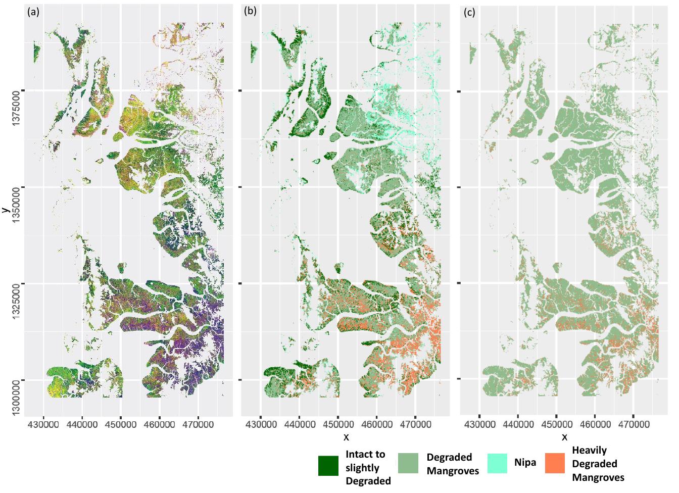
While Myanmar is one of the world’s hotspots for biodiversity and endemism, it is currently undergoing enormous political and economic transformations which are likely to increase the pressure on its already endangered forest ecosystems. In this context, mangrove forests are of particular relevance, as they are not only among the Earth’s most imperiled tropical environments, but also provide numerous ecosystem services to humanity. To ensure an ecologically worthwhile management of mangrove ecosystems, it is necessary that inventories are undertaken on a regular basis. Remote sensing offers a cost efficient and rapid method to periodically monitor mangrove forests. However, the current availability of various sensor types and different classification methods complicateswell-informed selection of the most appropriate methodology for an effective biodiversity monitoring. In order to assist applied ecologists in this highly complex decision-making process, this study compared the suitability of medium-resolution Landsat 8 and high-resolution RapidEye imagery to accurately monitor mangrove forests. Spatial and spectral resolution, classification algorithms and different predictor combinations were investigated as influencing elements. A multi-scale classification approach was developed to account for the fact that biodiversity monitoring for conservation is typically conducted on numerous spatial scales ranging from local to global perspectives. By formulating recommendation for practitioners, this study’s aim was to bridge the gap between research and its implementation in applied conservation. Results of the analysis showed that medium-resolution Landsat 8 imagery mostly leads to higher classification accuracies than high-resolution RapidEye data in the context of mangrove mapping in Southern Myanmar. The comparison of different predictor combinations suggested, that this difference is mainly attributable to the additional spectral bands provided by the Landsat 8 sensor. By investigating RapidEye images with spatial resolutions of 5 – 30 meters, it was discovered that overall classification accuracies increased with coarser spatial resolution regarding the majority of land cover classes. Moreover, the accuracy of land cover predictions was strongly influenced by the choice of specific classification algorithms as well as the number and characteristics of predictor layers. Referring to the main findings of this study, the application of medium-resolution Landsat 8 data is recommended to applied conservationists. This is based on its superior performance in most of the classifications as well as on its cost-free availability.
a