The deadline to apply for the EAGLE M.Sc. “Applied Earth Observation and Geoanalysis of the Living Environment” program is approaching quickly – applications must be submitted before midnight May 15th (CEST) for a winter term start in October.
Located at our EORC at the University of Würzburg in Germany and taught in English, EAGLE equips students with state‑of‑the‑art skills in remote sensing, spatial data analysis, environmental monitoring, and geospatial modelling – all tailored toward solving real‑world environmental problems.
🌍 Why You Should Apply (and What You Can Do With It)
EAGLE combines theoretical knowledge with practical tools to analyze Earth Observation data for real-world environmental challenges, from urban dynamics and biodiversity monitoring to land and water management. EAGLE blends rigorous methods with hands‑on applications – teaching students how to derive insights from satellite, airborne, and drone‑based Earth Observation data and integrate them into environmental decision‑making.
🔧 Hands-On Experience
Internships and innovation labs are part of the curriculum – and our students make use of these opportunities to gain real, field-based experience. Former students have completed internships in e.g.:
- monitoring Arctic ecosystems with drone and remote sensing methods in Svalbard in collaboration with UNIS researchers, combining aerial data with on‑ground ecological measurements.
- supporting fire and drought dynamics research in Kruger National Park, South Africa.
- contributing to wetland ecological conservation projects in the Seychelles using drone‑based environmental assessment.
These opportunities show how EAGLE students apply remote sensing beyond the classroom, working with NGOs, research institutions, and international partners and addressing environmental questions on multiple continents.
📚 Examples of EAGLE M.Sc. Thesis Projects
One of the most exciting parts of the EAGLE program is the opportunity to pursue research that has real environmental relevance. Recent MSc theses demonstrate how broad and impactful these projects can be:
🌡️ Modeling Urban Heat Exposure in Augsburg, Germany
In this thesis, a student combined very high resolution (VHR) remote sensing data with citizen science temperature measurements and machine learning to map fine‑scale urban heat exposure and vulnerabilities. The research produced a thermal exposure model and a Heat Vulnerability Index, a tool that can help city planners target heat mitigation strategies in urban environments.
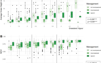
🏔️ High‑Arctic Vegetation Dynamics on Svalbard
Another EAGLE student spent a season in the Arctic collecting UAS multispectral data to monitor vegetation dynamics – including the effects of rain‑on‑snow events and goose grubbing – across different phenological stages. Her work helps link high‑resolution drone data with broader satellite observations to improve vegetation mapping in sensitive polar ecosystems.
❄️ Snowline Dynamics in Central Asia
Students have investigated sub‑seasonal changes in glacier snowlines across Central Asian mountain ranges using multi‑sensor satellite time series. This type of research enhances our understanding of cryosphere changes and climate impacts on water resources.
🤖 AI for Social and Environmental Mapping
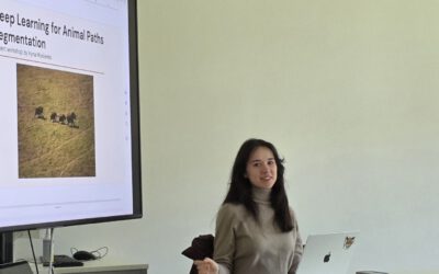
Projects such as mapping refugee camp extents using deep learning and Sentinel‑2 imagery show how remote sensing and machine learning can be brought to bear on humanitarian issues – connecting geospatial science with social challenges.
🌲 Forest Disturbance Detection
Other theses have focused on comparing different remote sensing models to detect forest disturbances – a key task for understanding the impacts of fire, pests, or logging on ecosystems.
🌍 SAR and Optical Methods for Flood and Land‑Cover Monitoring
Students have applied synthetic aperture radar (SAR) and deep learning to detect coastal urban flooding and to predict land cover change in places like Volcanoes National Park, Rwanda, demonstrating the program’s global relevance.
These examples reflect the program’s interdisciplinary breadth – from climate and cryosphere studies to urban vulnerability modelling, ecological monitoring, and applications in humanitarian contexts.
📈 What You’ll Gain
- 📊 Technical expertise in remote sensing, GIS, data analytics, and spatial modelling
- 🌐 Global perspective and interdisciplinary network
- 🧪 Hands‑on research experience with real datasets and complex environmental questions
- 💼 Career readiness for academia, NGOs, research institutes, and international organisations
Whether your interests are in climate adaptation, ecosystem conservation, urban resilience, or AI for geospatial problems, the skills gained in the EAGLE program are directly applicable to many professional paths.
📅 Apply Before It’s Too Late!
Make sure your application – including motivation letter, CV and transcripts – is submitted before May 15th (CEST) as a single PDF to be considered for the winter term.
👉 Visit the application portal here: www.eagle‑science.org/apply