fieldRS R package is out!

fieldRS R package is out!

August 3, 2018

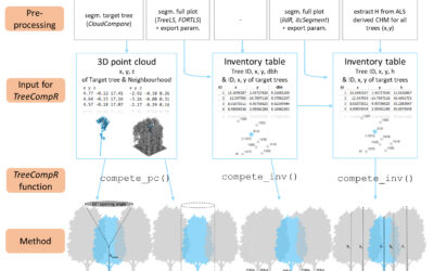
New package published in the scope of the Central Asia Waters (CAWa). fieldRS was designed to support scientists and practitioners in the collection of ground-truth data by helping design field campaigns. It provides tools to identify priority sampling sites, map potential sampling plots and convert those plots into consistent training and validation samples. currently, fieldRS addresses field campaigns related to land cover classification. Future updated will also consider the collection of ground-truth data used in the prediction of continuous variables. A vignette with detailed examples can be found here.

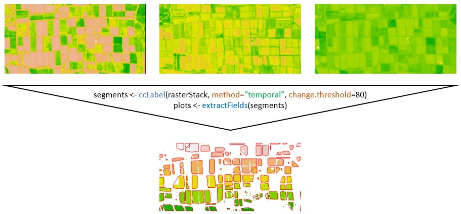
Translation of multi-temporal Normalized Difference Vegetation Index (NDVI) images into single sample plots using fieldRS.

you may also like:

Science Slam in Rosenheim: Hannes Taubenböck wins again

Science Slam in Rosenheim: Hannes Taubenböck wins again

After the completely surprising win of the Science Slam in Würzburg in November 2024 (we reported about it: https://remote-sensing.org/hannes-taubenbock-represents-eorc-at-the-science-slam-and-wins/), Hannes Taubenböck was invited to the Science Slam in Rosenheim. The...

Deep learning course by Thorsten Hoeser

Deep learning course by Thorsten Hoeser

This week Thorsten Hoeser, an expert in deep learning and data science, taught AI methods in remote sensing at our International EAGLE Earth Observation MSc Program. In this special module, Thorsten covered essential topics on the cutting-edge techniques for...

New Team Member: Sofia Haag

New Team Member: Sofia Haag

Sofia Haag joined the EORC in February 2025 as a research assistant for the EO4CAM project. After completing her Bachelor's degree in Geography at the University of Heidelberg, she pursued her Master's in Applied Physical Geography at the University of Würzburg. Sofia...