new publication on LST distribution

new publication on LST distribution

October 10, 2022

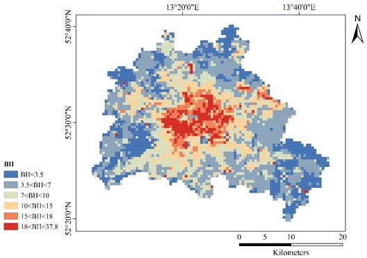
A new paper by Hannes Taubenböck and his team titled “Seasonal and Diurnal Variation of Land Surface Temperature Distribution and Its Relation to Land Use/Land Cover Patterns” has been published in the International Journal of Environmental Research and Public Health. From the abstract: “The surface urban heat island (SUHI) affects the quality of urban life. Because varying urban structures have varying impacts on SUHI, it is crucial to understand the impact of land use/land cover characteristics for improving the quality of life in cities and urban health. Satellite-based data on land surface temperatures (LST) and derived land use/cover pattern (LUCP) indicators provide an efficient opportunity to derive the required data at a large scale. This study explores the seasonal and diurnal variation of spatial associations from LUCP and LST employing Pearson correlation and ordinary least squares regression analysis. Specifically, Landsat-8 images were utilized to derive LSTs in four seasons, taking Berlin as a case study. The results indicate that: (1) in terms of land cover, hot spots are mainly distributed over transportation, commercial and industrial land in the daytime, while
wetlands were identified as hot spots during nighttime; (2) from the land composition indicators, the normalized difference built-up index (NDBI) showed the strongest influence in summer, while the normalized difference vegetation index (NDVI) exhibited the biggest impact in winter; (3) from urban morphological parameters, the building density showed an especially significant positive association with LST and the strongest effect during daytime.”

read the full article here:

https://www.mdpi.com/1660-4601/19/19/12738/pdf

you may also like:

Bridging Scales: How Radar Satellites supports Crop Monitoring

Bridging Scales: How Radar Satellites supports Crop Monitoring

In an era of climate uncertainty and increasing pressure on agricultural systems, understanding how crops grow and respond to environmental stress is more important than ever. A new study led by researchers from Martin-Luther-University Halle-Wittenberg, in close...

New paper on automated pollinator monitoring using time-lapse images

New paper on automated pollinator monitoring using time-lapse images

Researchers from Helmholtz Centre for Environmental Research (UFZ) in Leipzig, the German Centre for Integrative Biodiversity Research (iDiv) in Leipzig, the Martin Luther University Halle-Wittenberg, the German Remote Sensing Data Center (DFD) of the German Aerospace...

Media reporting on “understanding urban heat in Germany”

Media reporting on “understanding urban heat in Germany”

We recently reported on the urban heat island effect in Germany and the work of DLR and EORC on the topic – please see here: https://remote-sensing.org/understanding-urban-heat-in-germany-insights-from-prof-hannes-taubenbocks-research/   Here is a link to...

Proceedings of JURSE published

Proceedings of JURSE published

Our EORC and our colleagues from DLR have contributed with various research works to the Joint Urban Remote Sensing Event (JURSE) 2025. This bi-annual conference took place in Tunis, Tunisia, in early May 2025. JURSE is committed to introduce innovative methodologies...

DLR supports Zeit Magazine with Land Surface Temperature data

DLR supports Zeit Magazine with Land Surface Temperature data

Our colleagues from DLR provided long-term Land Surface Temperature (LST) data for an interactive tool in the Zeit Magazine which was recently published online https://www.zeit.de/zeit-magazin/2025-06/stadtteile-grossstaedte-wohnen-deutschland-lebensqualitaet The tool...