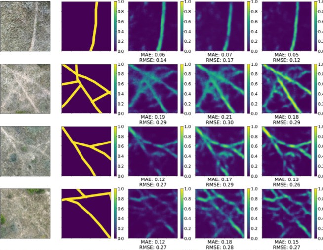

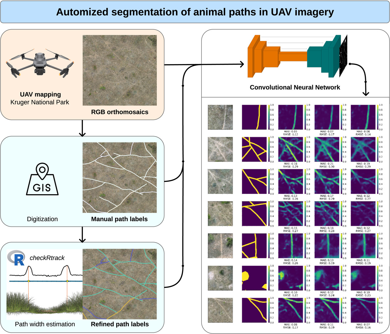
We’re pleased to share our latest open-access research on automatically detecting animal paths in Africa’s Kruger National Park using drone imagery and deep learning. Published in Ecological Informatics, our study demonstrates how deep learning can be employed to identify the network of trails created by animals as they move across the landscape. Using a UNet neural network architecture trained on high-resolution drone RGB imagery, we achieved up to 83% accuracy in automatically mapping animal paths. With paths often barely visible to the human eye, one major challenge is the generation of training data of adequate quality for the learning task. To address this, we additionally developed a semi-automatic digitization approach that estimates path width of manually digitized path labels from analyzing elevation differences in photogrammetrically derived terrain elevation data.
This research was made possible through close collaboration between the Earth Observation Research Cluster (EORC) at University of Würzburg and South African National Parks (SANParks). Our approach offers a scalable way to investigate how animals use their habitats, identify movement corridors etc. without the use of GPS collars. The method could complement traditional tracking by revealing spatially continuous route networks rather than discrete locations. We hope this work contributes to landscape-scale wildlife monitoring and conservation planning efforts. We are looking forward to publishing further research on the topic in the coming year.
The paper is openly available under the following link: https://www.sciencedirect.com/science/article/pii/S1574954125005795?via%3Dihub
Reference
Müller, K.1, Sonntag, L.1, Bevanda, M., Castañeda-Gomez, A. J., Wegmann, M., Wigley, B., Coetsee, C., Klein, D., Dech, S., Schwalb-Willmann, J. (2025): Automized segmentation of animal paths in UAS imagery using deep learning — a case study from the Kruger National Park. Ecological Informatics. 2025, 103570. https://doi.org/10.1016/j.ecoinf.2025.103570
1 Müller and Sonntag are equally contribution first authors.
Graphical Abstract:
Abstract:
The behaviour of terrestrial animals gives insights into their decision-making in relation to their local or inter-regional environment. Governed by this interaction, animals move across the landscape, leaving traces in the form of broad paths, trodden down trails, and stopping and resting areas. While GPS and radio-tracking provide valuable data on individual animal movements they are spatially and temporally limited due to fix errors and battery life. Hence, being able to identify continuous animal path systems is of great importance for understanding animal behavior and habitat utilization, complementing discrete geolocation data. In this work, we used photogrammetry-derived Red-Green-Blue (RGB) orthomosaics and digital surface models from Unoccupied Aerial System (UAS) imagery obtained in the Kruger National Park, South Africa. To automatically map animal paths, we used a UNet, a Deep Learning architecture. To generate training data, we developed a semi-automatic labeling approach to estimate the width of manually labeled animal paths, published alongside this work as an R package called checkRtrack. We investigated how different methods to derive animal path training data from imagery can enhance our network path segmentation performance. We show that our network is capable of correctly predicting up to 83% of animal paths on additionally created test data. High precision in path width estimation for training data generation was found to strongly improve the results of path segmentation by our network
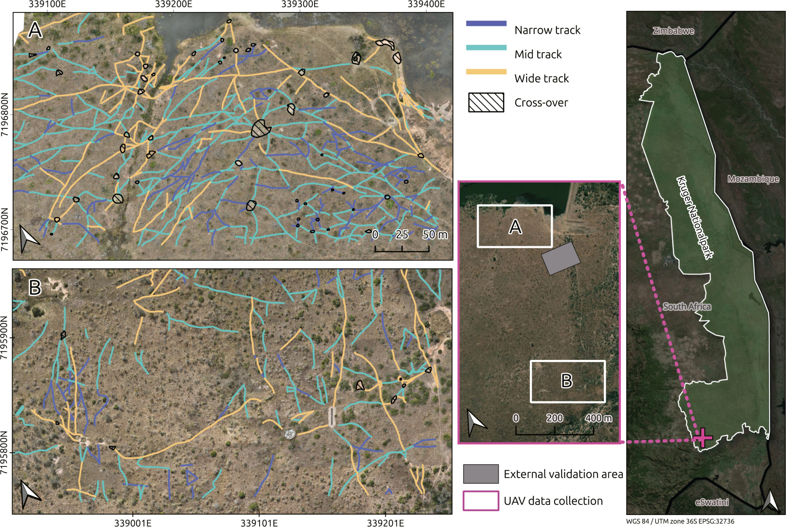
Map of the study area in Kruger National Park, South Africa